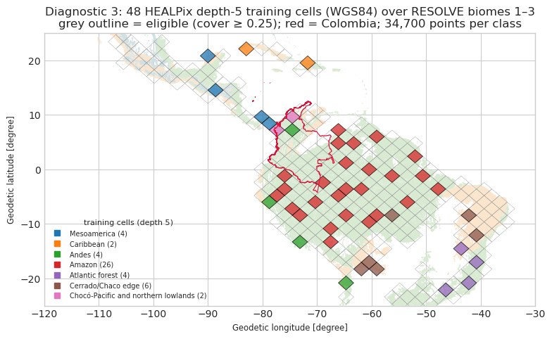
Our step-2 model is trained on Colombia only. Diagnostic 3 asks whether training
scope (pantropical in the paper vs Colombia here) explains why our model predicts
far less regrowth than the authors’ map. This notebook builds a Neotropical
training sample with the same definitions as 02b; 03d_transfer_test
uses it.
Domain. RESOLVE 2017 biomes 1–3 (tropical and subtropical moist, dry and coniferous forests), latitude −25…25°, longitude −120…−30° (the Americas).
Equal-area stratification. HEALPix depth-5 cells (NESTED, WGS84, about
200 km) are described on a 0.05° lattice: domain area, sub-region and biome.
Each cell is assigned to the stratum (sub-region × biome) that covers most of its
domain area. Cells with at least MIN_COVER of their area in the domain are
eligible. N_CELLS cells are drawn at random: one per stratum first, the rest
proportional to stratum area. Sub-regions come from an explicit RESOLVE
ecoregion → sub-region table (below).
Labels and pixels (as in 02b, on the 30 m Hansen lattice, pixel-centre rule).
Class 1 = domain ∩ Fagan et al. (2022) regrowth polygons; class 0 = domain −
forest 2000 − ESA CCI 2000 classes 150–153, 190, 200–202, 210 − all Fagan polygons.
Forest = Hansen v1.13 tree cover 2000 ≥ 30 %. Pixels are drawn by Bernoulli
sampling with inclusion probability ∝ exact pixel area, with per-cell rates, and
then capped at CAP_PER_CLASS points per class and cell, so that regrowth
hotspots do not dominate.
Predictors (2000; the Neotropical sample is used for training only). Forest
density (1 km-radius disk) and distance to forest (Euclidean, capped at 25 km),
computed on 1° tiles with a 0.25° margin exactly as in 02b; SoilGrids v2017
OCDENS / PHIHOX top 30 cm; bioclim PC1–PC4 with the existing PCA loadings
(data/clean/bioclim_pca_loadings.csv, not refitted); ESA CCI 2000 land cover
in the same 31 → 11 classes; biome.
Disk. Only point values are kept. Hansen tree-cover tiles are downloaded one
group at a time and deleted after use (the Colombian tiles in data/raw/hansen
are reused and kept); SoilGrids and ESA CCI are read remotely at the points;
WorldClim is read from the zip already in data/raw.
Smoke mode (SMOKE=1): three cells (one per sub-region, including the
Colombian smoke window), two 1° tiles per cell, cap 150; outputs in
data/clean_smoke/ and figures/smoke/.
import base64
import json
import multiprocessing as mp
import os
import shutil
import time
from concurrent.futures import ThreadPoolExecutor
from pathlib import Path

import geopandas as gpd
import matplotlib.pyplot as plt
import numpy as np
import pandas as pd
import rasterio
import requests
import shapely
import xarray as xr
from healpix_geo.nested import healpix_to_lonlat, lonlat_to_healpix, vertices
from matplotlib.collections import PolyCollection
from osgeo import gdal, ogr
from pyproj import Geod
from rasterio.features import rasterize
from rasterio.transform import from_origin
from rasterio.windows import Window, from_bounds
from scipy import ndimage, signal

gdal.UseExceptions()
ogr.UseExceptions()
for k, v in dict(GDAL_HTTP_MULTIRANGE="YES", GDAL_HTTP_MAX_RETRY="10", GDAL_HTTP_RETRY_DELAY="5",
                 CPL_VSIL_CURL_CHUNK_SIZE="4194304", GDAL_DISABLE_READDIR_ON_OPEN="EMPTY_DIR").items():
    gdal.SetConfigOption(k, v)
plt.style.use("seaborn-v0_8-whitegrid")
RAW = Path("../data/raw")
SMOKE = os.environ.get("SMOKE", "0") == "1"
CLEAN = Path("../data/clean_smoke" if SMOKE else "../data/clean")
FIGURES = Path("../figures/smoke" if SMOKE else "../figures")
TILE_CACHE = CLEAN / "neotropics_tiles"
HANSEN_TMP = RAW / "hansen_tmp_neotropics"
for d in (CLEAN, FIGURES, TILE_CACHE):
d.mkdir(parents=True, exist_ok=True)
# identical to 02b
RES = 0.00025
TILE_DEG, MARGIN_PX = 1, 1000
TILE_PX = int(round(TILE_DEG / RES))
TREE_THRESHOLD = 30
DENSITY_RADIUS_M = 1000.0
DIST_CAP_M = 25_000.0
SEED = 20261003
ESA_EXCL_TRAIN = [150, 151, 152, 153, 190, 200, 201, 202, 210]
FINAL_VARS = ["forest_density_2000", "dist_forest_2000", "ocdens", "phihox", "pc1", "pc2", "pc3", "pc4", "lc_2000", "biome"]
# diagnostic 3
REGION_BBOX = (-120.0, -25.0, -30.0, 25.0)
CELL_DEPTH = 5
LATTICE_RES = 0.05
MIN_COVER = 0.25
N_CELLS = 3 if SMOKE else 48
CAP_PER_CLASS = 150 if SMOKE else 1000
OVERSAMPLE1, OVERSAMPLE0 = 3.0, 30.0 # expected candidates / cap: class 1 per regrowth pixel, class 0 per domain pixel
VAL_SHARE = 0.25
MIN_FREE_GB = 10.0
N_WORKERS = int(os.environ.get("N_WORKERS", 4 if SMOKE else min(12, os.cpu_count() or 1)))
print(f"smoke={SMOKE} cells={N_CELLS} cap={CAP_PER_CLASS} workers={N_WORKERS}")
WGS84_A, WGS84_F = 6378137.0, 1 / 298.257223563
E2 = WGS84_F * (2 - WGS84_F)
EC = np.sqrt(E2)
def _q(phi: np.ndarray) -> np.ndarray:
s = np.sin(phi)
return (1 - E2) * (s / (1 - E2 * s * s) - np.log((1 - EC * s) / (1 + EC * s)) / (2 * EC))
def area_ellipsoid(lat_top: np.ndarray, res: float = RES) -> np.ndarray:
"""Exact WGS84 area (m²) of a res × res lon/lat cell whose top edge is at lat_top (02b, res as argument)."""
return WGS84_A**2 / 2 * np.radians(res) * (_q(np.radians(lat_top)) - _q(np.radians(lat_top - res)))
def metres_per_degree(lat: float) -> tuple[float, float]:
phi = np.radians(lat)
s2 = np.sin(phi) ** 2
m = WGS84_A * (1 - E2) / (1 - E2 * s2) ** 1.5
n = WGS84_A / np.sqrt(1 - E2 * s2)
return float(np.radians(1) * m), float(np.radians(1) * n * np.cos(phi))
def free_gb(path: Path = RAW) -> float:
return shutil.disk_usage(path).free / 1e9
HP_CELL_AREA = 4 * np.pi * (WGS84_A**2 / 2 * _q(np.pi / 2)) / (12 * 4**CELL_DEPTH) # authalic sphere, equal-area cells
print(f"free disk {free_gb():.1f} GB; HEALPix depth-{CELL_DEPTH} cell area {HP_CELL_AREA / 1e6:,.0f} km²")smoke=False cells=48 cap=1000 workers=12
free disk 22.7 GB; HEALPix depth-5 cell area 41,509 km²
1. Domain and sub-regions (RESOLVE 2017)
Sub-regions from the RESOLVE ecoregion names. Ecoregions that fit none of the six named sub-regions (Chocó–Pacific coast, Caribbean coast of South America, Llanos edge) form a seventh stratum, “Chocó-Pacific and northern lowlands”, so that every domain pixel belongs to a sub-region. The Guiana Shield is grouped with the Amazon. “Cerrado/Chaco edge” holds the dry forests of the South American dry diagonal (Cerrado and Chaco themselves are savanna biomes and outside the domain).
SUBREGIONS = {
    "Mesoamerica": [
        "Central American Atlantic moist forests", "Central American montane forests", "Chiapas montane forests",
        "Chimalapas montane forests", "Costa Rican seasonal moist forests", "Eastern Panamanian montane forests",
        "Isthmian-Atlantic moist forests", "Isthmian-Pacific moist forests", "Oaxacan montane forests",
        "Pantanos de Centla", "Petén-Veracruz moist forests", "Sierra Madre de Chiapas moist forests",
        "Sierra de los Tuxtlas", "Talamancan montane forests", "Veracruz moist forests", "Veracruz montane forests",
        "Yucatán moist forests", "Cocos Island moist forests", "Cayos Miskitos-San Andrés and Providencia moist forests",
        "Bajío dry forests", "Balsas dry forests", "Central American dry forests", "Chiapas Depression dry forests",
        "Islas Revillagigedo dry forests", "Jalisco dry forests", "Panamanian dry forests", "Sierra de la Laguna dry forests",
        "Sinaloan dry forests", "Southern Pacific dry forests", "Veracruz dry forests", "Yucatán dry forests",
        "Central American pine-oak forests", "Sierra Madre Occidental pine-oak forests",
        "Sierra Madre Oriental pine-oak forests", "Sierra Madre de Oaxaca pine-oak forests",
        "Sierra Madre del Sur pine-oak forests", "Sierra de la Laguna pine-oak forests",
        "Trans-Mexican Volcanic Belt pine-oak forests"],
    "Caribbean": [
        "Cuban moist forests", "Hispaniolan moist forests", "Jamaican moist forests", "Leeward Islands moist forests",
        "Puerto Rican moist forests", "Windward Islands moist forests", "Trinidad and Tobago moist forest",
        "Cuban dry forests", "Hispaniolan dry forests", "Jamaican dry forests", "Lesser Antillean dry forests",
        "Puerto Rican dry forests", "Trinidad and Tobago dry forest", "Bahamian pineyards", "Cuban pine forests",
        "Hispaniolan pine forests"],
    "Andes": [
        "Bolivian Yungas", "Peruvian Yungas", "Southern Andean Yungas", "Cauca Valley montane forests",
        "Cordillera Oriental montane forests", "Eastern Cordillera Real montane forests",
        "Northwest Andean montane forests", "Magdalena Valley montane forests", "Santa Marta montane forests",
        "Venezuelan Andes montane forests", "Cordillera La Costa montane forests", "Marañón dry forests",
        "Cauca Valley dry forests", "Magdalena Valley dry forests", "Patía valley dry forests",
        "Bolivian montane dry forests"],
    "Amazon": [
        "Caqueta moist forests", "Gurupa várzea", "Iquitos várzea", "Japurá-Solimões-Negro moist forests",
        "Juruá-Purus moist forests", "Madeira-Tapajós moist forests", "Marajó várzea", "Monte Alegre várzea",
        "Napo moist forests", "Negro-Branco moist forests", "Purus várzea", "Purus-Madeira moist forests",
        "Rio Negro campinarana", "Solimões-Japurá moist forests", "Southwest Amazon moist forests",
        "Tapajós-Xingu moist forests", "Tocantins/Pindare moist forests", "Uatumã-Trombetas moist forests",
        "Ucayali moist forests", "Xingu-Tocantins-Araguaia moist forests", "Guianan Highlands moist forests",
        "Guianan freshwater swamp forests", "Guianan lowland moist forests", "Guianan piedmont moist forests",
        "Pantepui forests & shrublands"],
    "Atlantic forest": [
        "Alto Paraná Atlantic forests", "Araucaria moist forests", "Atlantic Coast restingas", "Bahia coastal forests",
        "Bahia interior forests", "Caatinga Enclaves moist forests", "Fernando de Noronha-Atol das Rocas moist forests",
        "Northeast Brazil restingas", "Pernambuco coastal forests", "Pernambuco interior forests",
        "Serra do Mar coastal forests", "Trindade-Martin Vaz Islands tropical forests", "Brazilian Atlantic dry forests"],
    "Cerrado/Chaco edge": [
        "Chiquitano dry forests", "Mato Grosso tropical dry forests", "Caatinga", "Maranhão Babaçu forests"],
    "Chocó-Pacific and northern lowlands": [
        "Chocó-Darién moist forests", "Western Ecuador moist forests", "Magdalena-Urabá moist forests",
        "Catatumbo moist forests", "Orinoco Delta swamp forests", "Apure-Villavicencio dry forests",
        "Ecuadorian dry forests", "Tumbes-Piura dry forests", "Lara-Falcón dry forests", "Maracaibo dry forests",
        "Sinú Valley dry forests"],
}
ECO_TO_SUB = {e: s for s, es in SUBREGIONS.items() for e in es}

eco = gpd.read_file(f"/vsizip/{(RAW / 'ecoregions' / 'Ecoregions2017.zip').resolve()}", bbox=REGION_BBOX)
eco = eco[eco.BIOME_NUM.isin([1, 2, 3])][["ECO_ID", "ECO_NAME", "BIOME_NUM", "geometry"]].copy()
eco["geometry"] = shapely.clip_by_rect(shapely.make_valid(eco.geometry.values), *REGION_BBOX)
eco = eco[~eco.geometry.is_empty].reset_index(drop=True)
eco["BIOME_NUM"] = eco.BIOME_NUM.astype(int)
eco["subregion"] = eco.ECO_NAME.map(ECO_TO_SUB)
assert eco.subregion.notna().all(), eco.loc[eco.subregion.isna(), "ECO_NAME"].tolist()
eco_tree = shapely.STRtree(eco.geometry.values)
print(eco.groupby(["subregion", "BIOME_NUM"]).size().to_string())

col = gpd.read_file(RAW / "gadm" / "gadm41_COL.gpkg", layer="ADM_ADM_0")
COL_GEOM = shapely.make_valid(col.geometry.iloc[0])
subregion BIOME_NUM
Amazon 1 25
Andes 1 12
2 4
Atlantic forest 1 12
2 1
Caribbean 1 7
2 6
3 3
Cerrado/Chaco edge 1 1
2 3
Chocó-Pacific and northern lowlands 1 5
2 6
Mesoamerica 1 19
2 12
3 7
2. HEALPix depth-5 cells on a 0.05° lattice, strata and selection
W, S, E, N = REGION_BBOX
lshape = (int(round((N - S) / LATTICE_RES)), int(round((E - W) / LATTICE_RES)))
ltr = from_origin(W, N, LATTICE_RES, LATTICE_RES)
eco_idx = rasterize(((g, i + 1) for i, g in enumerate(eco.geometry)), out_shape=lshape, transform=ltr, fill=0,
                    dtype="int32")
rr, cc = np.nonzero(eco_idx)
llat = N - (rr + 0.5) * LATTICE_RES
llon = W + (cc + 0.5) * LATTICE_RES
lat_df = pd.DataFrame({
    "lon": llon, "lat": llat, "area": area_ellipsoid(llat + LATTICE_RES / 2, LATTICE_RES),
    "cell": lonlat_to_healpix(llon, llat, CELL_DEPTH, ellipsoid="WGS84").astype("uint64"),
    "subregion": eco.subregion.to_numpy()[eco_idx[rr, cc] - 1], "biome": eco.BIOME_NUM.to_numpy()[eco_idx[rr, cc] - 1],
    "colombia": shapely.contains_xy(COL_GEOM, llon, llat),
})
by = lat_df.groupby(["cell", "subregion", "biome"]).area.sum().reset_index()
dom = by.loc[by.groupby("cell").area.idxmax()].set_index("cell")[["subregion", "biome"]]
cells = lat_df.groupby("cell").area.sum().rename("domain_area").to_frame().join(dom)
cells["colombia_area"] = lat_df[lat_df.colombia].groupby("cell").area.sum().reindex(cells.index).fillna(0.0)
cells["cover"] = cells.domain_area / HP_CELL_AREA
cells["stratum"] = cells.subregion + " | biome " + cells.biome.astype(str)
cells["eligible"] = cells.cover >= MIN_COVER
clon, clat = healpix_to_lonlat(cells.index.to_numpy(), CELL_DEPTH, ellipsoid="WGS84")
cells["lon"], cells["lat"] = (np.asarray(clon) + 180) % 360 - 180, np.asarray(clat)
print(f"{len(cells)} depth-{CELL_DEPTH} cells touch the domain; {cells.eligible.sum()} have cover >= {MIN_COVER}")
strata = (cells[cells.eligible].groupby("stratum")
          .agg(n_eligible=("cover", "size"), domain_area=("domain_area", "sum")).sort_values("domain_area", ascending=False))
print(strata.assign(domain_mkm2=strata.domain_area / 1e12).drop(columns="domain_area").to_string())
457 depth-5 cells touch the domain; 313 have cover >= 0.25
n_eligible domain_mkm2
stratum
Amazon | biome 1 150 5.765054
Cerrado/Chaco edge | biome 2 34 1.145268
Atlantic forest | biome 1 27 0.750963
Andes | biome 1 21 0.687988
Mesoamerica | biome 1 21 0.601044
Cerrado/Chaco edge | biome 1 11 0.376050
Mesoamerica | biome 3 12 0.335076
Mesoamerica | biome 2 11 0.292952
Chocó-Pacific and northern lowlands | biome 2 9 0.248031
Chocó-Pacific and northern lowlands | biome 1 5 0.146958
Atlantic forest | biome 2 3 0.075675
Andes | biome 2 2 0.066989
Caribbean | biome 2 4 0.064884
Caribbean | biome 1 3 0.058971
rng = np.random.default_rng(SEED)
alloc = pd.Series(1, index=strata.index)
rest = (48 if SMOKE else N_CELLS) - alloc.sum()  # smoke: allocation code runs, then three cells replace it
assert rest >= 0, f"N_CELLS={N_CELLS} < number of strata {len(strata)}"
while rest > 0:
    room = strata.n_eligible - alloc
    share = strata.domain_area.where(room > 0, 0.0)
    target = share / share.sum() * (alloc.sum() + rest)
    k = (target - alloc).where(room > 0, -np.inf).idxmax()
    alloc[k] += 1
    rest -= 1
selected = []
for st, k in alloc.items():
    cand = cells[cells.eligible & (cells.stratum == st)].index.to_numpy()
    selected.extend(rng.choice(cand, size=min(k, len(cand)), replace=False).tolist())
if SMOKE:
    smoke_cell = int(lonlat_to_healpix(np.array([-74.0]), np.array([5.0]), CELL_DEPTH, ellipsoid="WGS84")[0])
    picks = [smoke_cell]
    for sub in ["Mesoamerica", "Atlantic forest"]:
        c = cells[cells.eligible & (cells.subregion == sub)].sort_values("cover", ascending=False)
        picks.append(int(c.index[0]))
    selected = picks
    alloc = cells.loc[picks].groupby("stratum").size()
cells["selected"] = cells.index.isin(selected)
sel = cells[cells.selected].copy()
print(f"{len(sel)} cells selected, {int((sel.colombia_area > 0).sum())} touch Colombia")
print(sel.groupby(["subregion", "biome"]).size().to_string())
48 cells selected, 4 touch Colombia
subregion biome
Amazon 1 26
Andes 1 3
2 1
Atlantic forest 1 3
2 1
Caribbean 1 1
2 1
Cerrado/Chaco edge 1 1
2 5
Chocó-Pacific and northern lowlands 1 1
2 1
Mesoamerica 1 2
2 1
3 1
3. Fagan et al. (2022) polygons in the selected cells (remote, per layer and bbox)
FAGAN_URL = ("https://gfw2-data.s3.amazonaws.com/plantations/pantropical_tree_plantation_expansion/"
             "pantropical_tree_plantation_expansion_2000_2012.gpkg")
# Null pred3class: gain patches Fagan et al. left unclassified (e.g. missing Sentinel-1
# data); code 4 keeps them out of both classes (class 0 requires code 0).
FAGAN_CODE = {"regrowth": 1, "plantation": 2, "open": 3}


def cell_polygon(cell: int) -> shapely.Polygon:
    lon, lat = vertices(np.array([cell], dtype="uint64"), CELL_DEPTH, ellipsoid="WGS84")
    lon = (np.asarray(lon)[0] + 180) % 360 - 180
    return shapely.Polygon(np.column_stack([lon, np.asarray(lat)[0]]))


sel["bbox"] = [shapely.buffer(cell_polygon(c), 0.1).bounds for c in sel.index]
fagan_out = RAW / "fagan" / ("fagan2022_neotropics_smoke.parquet" if SMOKE else "fagan2022_neotropics_cells.parquet")
fagan_cells = fagan_out.with_suffix(".cells.json")
if fagan_out.exists() and (not fagan_cells.exists() or json.load(open(fagan_cells)) != sorted(int(c) for c in sel.index)):
    fagan_out.unlink()  # cached for another cell selection


def fagan_cell(bbox: tuple[float, float, float, float]) -> list[tuple]:
    """All Fagan features whose envelope intersects bbox, from every layer (own OGR connection per thread)."""
    x0, y0, x1, y1 = bbox
    ds = ogr.Open("/vsicurl/" + FAGAN_URL)
    out = []
    for i in range(ds.GetLayerCount()):
        layer = ds.GetLayer(i)
        lx0, lx1, ly0, ly1 = layer.GetExtent()
        if lx1 < x0 or lx0 > x1 or ly1 < y0 or ly0 > y1:
            continue
        layer.SetSpatialFilterRect(x0, y0, x1, y1)
        out += [(layer.GetName(), f.GetFID(), f.GetField("pred3class"), f.GetField("conf_rank"),
                 bytes(f.GetGeometryRef().ExportToWkb())) for f in layer]
    return out


if not fagan_out.exists():
    t0 = time.time()
    with ThreadPoolExecutor(8) as ex:
        parts = list(ex.map(fagan_cell, sel.bbox))
    df = (pd.DataFrame([r for part in parts for r in part], columns=["layer", "fid", "pred3class", "conf_rank", "wkb"])
          .drop_duplicates(["layer", "fid"]))
    print(f"Fagan features read in {time.time() - t0:.0f} s")
    fagan = gpd.GeoDataFrame(df.drop(columns="wkb"), geometry=shapely.from_wkb(df.wkb), crs="EPSG:4326")
    fagan.to_parquet(fagan_out)
    json.dump(sorted(int(c) for c in sel.index), open(fagan_cells, "w"))
fagan = gpd.read_parquet(fagan_out)
fagan["code"] = fagan.pred3class.map(FAGAN_CODE).fillna(4).astype("uint8")
fagan_tree = shapely.STRtree(fagan.geometry.values)
print(len(fagan), "Fagan polygons;", fagan.pred3class.value_counts().to_dict())
578340 Fagan polygons; {'regrowth': 387080, 'plantation': 170620, 'open': 20364}
Per-cell Bernoulli rates. The class-1 rate uses the geodesic area of the regrowth polygons whose representative point is in the cell; the class-0 rate uses the cell’s domain area. Rates only set how many candidates are drawn; the cap then fixes the per-cell count.
geod = Geod(ellps="WGS84")
reg = fagan[fagan.code == 1]
rp = shapely.point_on_surface(reg.geometry.values)
reg_cell = lonlat_to_healpix(shapely.get_x(rp), shapely.get_y(rp), CELL_DEPTH, ellipsoid="WGS84").astype("uint64")
reg_area = np.array([abs(geod.geometry_area_perimeter(g)[0]) for g in reg.geometry.values])
sel["regrowth_area"] = pd.Series(reg_area).groupby(reg_cell).sum().reindex(sel.index).fillna(0.0).to_numpy()
pix = area_ellipsoid(sel.lat.to_numpy() + RES / 2)
sel["rate1"] = np.minimum(1.0, OVERSAMPLE1 * CAP_PER_CLASS / np.maximum(sel.regrowth_area / pix, 1.0))
sel["rate0"] = np.minimum(1.0, OVERSAMPLE0 * CAP_PER_CLASS / (sel.domain_area / pix))
RATE_CELLS = pd.Index(sel.index.to_numpy().astype("uint64"))
RATE1, RATE0 = sel.rate1.to_numpy(), sel.rate0.to_numpy()
print(sel[["subregion", "biome", "cover", "regrowth_area", "rate1", "rate0"]]
      .assign(regrowth_ha=lambda d: d.regrowth_area / 1e4).drop(columns="regrowth_area").round(5).to_string())
subregion biome cover rate1 rate0 regrowth_ha
cell
7436 Amazon 1 0.59627 0.03547 0.00091 6336.86643
7439 Amazon 1 0.96955 0.03790 0.00056 5983.81344
7446 Amazon 1 1.00019 0.08565 0.00055 2657.69100
7447 Amazon 1 1.00054 0.72679 0.00055 314.22065
7451 Amazon 1 1.00054 0.02212 0.00055 10324.20633
7456 Andes 1 0.77843 0.31162 0.00070 721.26576
7468 Amazon 1 0.99980 0.03283 0.00055 6956.64958
7470 Amazon 1 0.99895 0.02636 0.00055 8687.19913
7478 Amazon 1 1.00031 0.17634 0.00055 1304.36664
7479 Amazon 1 1.00034 0.02715 0.00055 8485.36401
7480 Amazon 1 0.99690 0.20174 0.00055 1137.93746
7486 Amazon 1 0.99919 0.40746 0.00056 565.94272
7488 Cerrado/Chaco edge 1 1.00054 0.08830 0.00055 2586.44625
7492 Amazon 1 0.99690 0.11501 0.00055 1996.00809
7503 Amazon 1 1.00057 0.02214 0.00056 10422.62785
7507 Amazon 1 0.96795 0.15571 0.00057 1481.90588
7518 Amazon 1 0.98437 0.42422 0.00056 543.57653
7520 Amazon 1 0.99886 0.05013 0.00056 4595.04788
7526 Amazon 1 0.99930 0.06458 0.00056 3573.77991
7531 Amazon 1 1.00057 1.00000 0.00056 192.97643
7547 Amazon 1 0.99101 0.09883 0.00056 2322.84445
7555 Andes 1 0.94537 0.13222 0.00058 1736.24909
7558 Amazon 1 1.00031 0.06306 0.00055 3647.69935
7559 Amazon 1 1.00034 0.33589 0.00055 685.80163
7576 Amazon 1 1.00057 0.38732 0.00056 595.75634
7613 Chocó-Pacific and northern lowlands 1 0.73546 0.09287 0.00075 2466.07726
7615 Mesoamerica 1 0.38998 0.05562 0.00141 4105.62898
7621 Amazon 1 1.00105 0.48617 0.00055 473.10059
7622 Amazon 1 1.00031 0.15921 0.00055 1444.69625
7629 Amazon 1 0.39463 0.24110 0.00140 949.86698
7650 Andes 1 0.99895 0.01272 0.00055 18008.48308
7657 Chocó-Pacific and northern lowlands 2 0.86866 0.00699 0.00063 32557.45041
7957 Mesoamerica 1 0.26290 0.09861 0.00209 2308.32961
7990 Mesoamerica 3 0.99254 0.04981 0.00054 4489.05471
8022 Caribbean 1 0.65099 0.05937 0.00081 3668.64956
8045 Caribbean 2 0.26228 0.00752 0.00197 28476.66608
8128 Mesoamerica 2 0.51522 0.00405 0.00101 53293.97464
12094 Atlantic forest 1 0.73831 0.27868 0.00070 768.71128
12136 Atlantic forest 1 0.97228 0.35966 0.00054 600.78145
12142 Atlantic forest 1 0.97997 0.12556 0.00054 1759.48847
12199 Cerrado/Chaco edge 2 0.58843 0.77714 0.00090 282.35382
12200 Andes 2 0.69193 0.39456 0.00075 547.64254
12204 Cerrado/Chaco edge 2 0.31820 0.19934 0.00166 1100.78532
12205 Cerrado/Chaco edge 2 0.80966 0.12857 0.00066 1718.30613
12230 Atlantic forest 2 0.90211 0.19480 0.00060 1147.80075
12242 Cerrado/Chaco edge 2 0.97849 0.08975 0.00056 2516.21065
12251 Cerrado/Chaco edge 2 1.00054 0.20192 0.00055 1130.97965
12283 Amazon 1 1.00034 0.00383 0.00055 60076.07496
4. 1° tiles and Hansen tree-cover tiles
Work tiles = 1° tiles holding at least one lattice point of a selected cell’s domain. Each needs the 10° Hansen tiles under its 0.25° margin.
SEL_SET = set(int(c) for c in sel.index)
in_sel = lat_df[lat_df.cell.isin(sel.index)]
tiles = sorted(set(zip(np.floor(in_sel.lon).astype(int), np.floor(in_sel.lat).astype(int))))
if SMOKE:
    per_cell = in_sel.assign(t=list(zip(np.floor(in_sel.lon).astype(int), np.floor(in_sel.lat).astype(int))))
    tiles = sorted({t for _, g in per_cell.groupby("cell") for t in g.t.value_counts().index[:2]})
GFC = "https://storage.googleapis.com/earthenginepartners-hansen/GFC-2025-v1.13/Hansen_GFC-2025-v1.13_{layer}_{tile}.tif"


def hansen_name(left: int, top: int) -> str:
    return f"{abs(top):02d}{'N' if top >= 0 else 'S'}_{abs(left):03d}{'W' if left < 0 else 'E'}"


def hansen_needed(tile: tuple[int, int]) -> list[str]:
    lon0, lat0 = tile
    m = MARGIN_PX * RES
    x0, x1, y0, y1 = lon0 - m, lon0 + 1 + m, lat0 - m, lat0 + 1 + m
    out = []
    for left in range(int(np.floor(x0 / 10) * 10), int(np.ceil(x1 / 10) * 10), 10):
        for top in range(int(np.floor(y0 / 10) * 10) + 10, int(np.ceil(y1 / 10) * 10) + 10, 10):
            out.append(hansen_name(left, top))
    return out


def primary_hansen(tile: tuple[int, int]) -> str:
    return hansen_name(int(np.floor(tile[0] / 10) * 10), int(np.floor(tile[1] / 10) * 10) + 10)


groups: dict[str, list] = {}
for t in tiles:
    groups.setdefault(primary_hansen(t), []).append(t)
needs = {h: sorted({n for t in ts for n in hansen_needed(t)}) for h, ts in groups.items()}
all_needed = sorted({n for v in needs.values() for n in v})
print(f"{len(tiles)} work tiles in {len(groups)} Hansen groups; {len(all_needed)} Hansen tiles needed:", all_needed)


def gcs_md5(url: str) -> str | None:
    head = requests.head(url, timeout=60)
    if head.status_code == 404:
        return "missing"
    head.raise_for_status()
    for part in head.headers.get("x-goog-hash", "").split(","):
        k, _, v = part.strip().partition("=")
        if k == "md5":
            return base64.b64decode(v + "=" * (-len(v) % 4)).hex()
    return None


def file_md5(path: Path) -> str:
    import hashlib
    h = hashlib.md5()
    with open(path, "rb") as f:
        while block := f.read(1 << 22):
            h.update(block)
    return h.hexdigest()


def hansen_local(name: str) -> Path | None:
    """Local tree-cover tile: the kept Colombian download, or a temporary download (md5-checked)."""
    fn = Path(GFC.format(layer="treecover2000", tile=name)).name
    if (RAW / "hansen" / fn).exists():
        return RAW / "hansen" / fn
    out = HANSEN_TMP / fn
    if out.exists():
        return out
    url = GFC.format(layer="treecover2000", tile=name)
    md5 = gcs_md5(url)
    if md5 == "missing":
        return None
    size = int(requests.head(url, timeout=60).headers["Content-Length"]) / 1e9
    if free_gb() - size < MIN_FREE_GB:
        raise RuntimeError(f"only {free_gb():.1f} GB free; refusing to download {fn} ({size:.2f} GB)")
    HANSEN_TMP.mkdir(parents=True, exist_ok=True)
    tmp = out.with_suffix(".part")
    for attempt in range(6):
        try:
            with requests.get(url, stream=True, timeout=600) as r:
                r.raise_for_status()
                with open(tmp, "wb") as f:
                    shutil.copyfileobj(r.raw, f, length=1 << 22)
            if md5 is None or file_md5(tmp) == md5:
                break
            raise OSError("md5 mismatch")
        except (requests.RequestException, OSError) as err:
            if attempt == 5:
                raise
            print(f"  retry {attempt + 1} {fn}: {err}")
            time.sleep(10 * (attempt + 1))
    tmp.rename(out)
    return out
371 work tiles in 21 Hansen groups; 27 Hansen tiles needed: ['00N_040W', '00N_050W', '00N_060W', '00N_070W', '00N_080W', '00N_090W', '10N_050W', '10N_060W', '10N_070W', '10N_080W', '10N_090W', '10S_040W', '10S_050W', '10S_060W', '10S_070W', '10S_080W', '20N_070W', '20N_080W', '20N_090W', '20N_100W', '20S_040W', '20S_050W', '20S_070W', '30N_070W', '30N_080W', '30N_090W', '30N_100W']
5. Per-tile worker (masks, focal predictors and sampling as in 02b)
HANSEN_VRT: str | None = None


def disk_kernel(radius_m: float, dy: float, dx: float) -> np.ndarray:
    ry, rx = int(np.ceil(radius_m / dy)), int(np.ceil(radius_m / dx))
    yy, xx = np.mgrid[-ry:ry + 1, -rx:rx + 1]
    k = ((yy * dy) ** 2 + (xx * dx) ** 2 <= radius_m**2).astype("float32")
    return k / k.sum()


def focal(forest: np.ndarray, kernel: np.ndarray, dy: float, dx: float, m: int) -> tuple[np.ndarray, np.ndarray]:
    kr, kc = kernel.shape[0] // 2, kernel.shape[1] // 2
    sub = forest[m - kr:m + TILE_PX + kr, m - kc:m + TILE_PX + kc].astype("float32")
    dens = signal.fftconvolve(sub, kernel, mode="valid")
    if forest.any():
        dist = ndimage.distance_transform_edt(~forest, sampling=(dy, dx))[m:m + TILE_PX, m:m + TILE_PX]
    else:
        dist = np.full((TILE_PX, TILE_PX), np.inf)
    return np.clip(dens, 0, 1).astype("float32"), np.minimum(dist, DIST_CAP_M).astype("float32")


def process_tile(tile: tuple[int, int]) -> pd.DataFrame:
    lon0, lat0 = tile
    rng = np.random.default_rng([SEED, lon0 + 1000, lat0 + 1000, 3])
    m = MARGIN_PX
    left, top = lon0 - m * RES, lat0 + 1 + m * RES
    size = TILE_PX + 2 * m
    if HANSEN_VRT is None:
        tc = np.zeros((size, size), dtype="uint8")
    else:
        with rasterio.open(HANSEN_VRT) as src:
            w = from_bounds(left, top - size * RES, left + size * RES, top, src.transform).round_offsets().round_lengths()
            tc = src.read(1, window=Window(w.col_off, w.row_off, size, size), boundless=True, fill_value=0)
    forest00 = tc >= TREE_THRESHOLD
    del tc
    my, mx = metres_per_degree(lat0 + 0.5)
    dy, dx = RES * my, RES * mx
    dens00, dist00 = focal(forest00, disk_kernel(DENSITY_RADIUS_M, dy, dx), dy, dx, m)
    f00 = forest00[m:m + TILE_PX, m:m + TILE_PX]
    del forest00

    core_tr = from_origin(lon0, lat0 + 1, RES, RES)
    shape = (TILE_PX, TILE_PX)
    tbox = shapely.box(lon0, lat0, lon0 + 1, lat0 + 1)
    ie = eco_tree.query(tbox)
    bshapes = [(shapely.clip_by_rect(g, *tbox.bounds), int(b))
               for g, b in zip(eco.geometry.values[ie], eco.BIOME_NUM.values[ie])]
    bshapes = [(g, b) for g, b in bshapes if not g.is_empty]
    biome = rasterize(bshapes, out_shape=shape, transform=core_tr, fill=0, dtype="uint8") if bshapes else np.zeros(shape, "uint8")
    idx = fagan_tree.query(tbox)
    fsub = fagan.iloc[idx].sort_values("code", ascending=False)  # regrowth (1) burned in last = wins overlaps
    fag = (rasterize(((g, int(c)) for g, c in zip(fsub.geometry, fsub.code)), out_shape=shape, transform=core_tr,
                     fill=0, dtype="uint8") if len(fsub) else np.zeros(shape, "uint8"))
    lat_c = lat0 + 1 - (np.arange(TILE_PX) + 0.5) * RES
    lon_c = lon0 + (np.arange(TILE_PX) + 0.5) * RES
    dom = np.isin(biome, [1, 2, 3]) & (lat_c >= REGION_BBOX[1])[:, None] & (lat_c <= REGION_BBOX[3])[:, None]
    cls1 = dom & (fag == 1)
    cls0 = dom & ~f00 & (fag == 0)  # ESA CCI 2000 exclusions are applied at the points (section 6)

    a_ell = area_ellipsoid(lat_c + RES / 2)[:, None]
    w_area = a_ell / a_ell.max()
    u = rng.random(shape)
    cand = (cls1 & (u < RATE1.max() * w_area)) | (cls0 & (u < RATE0.max() * w_area))
    r, c = np.nonzero(cand)
    lon, lat = lon_c[c], lat_c[r]
    cell = lonlat_to_healpix(lon, lat, CELL_DEPTH, ellipsoid="WGS84").astype("uint64")
    lab = np.where(cls1[r, c], 1, 0).astype("int8")
    pos = RATE_CELLS.get_indexer(cell)
    rate = np.where(pos < 0, 0.0, np.where(lab == 1, RATE1[pos], RATE0[pos]))  # outside the selected cells: 0
    keep = u[r, c] < rate * w_area[r, 0]
    r, c, lon, lat, cell, lab = r[keep], c[keep], lon[keep], lat[keep], cell[keep], lab[keep]
    grow0 = int(round((90 - (lat0 + 1)) / RES))
    gcol0 = int(round((lon0 + 180) / RES))
    return pd.DataFrame({
        "lon": lon, "lat": lat, "grow": grow0 + r, "gcol": gcol0 + c, "area_ell": a_ell[r, 0], "label": lab,
        "cell5": cell, "fagan_code": fag[r, c], "biome": biome[r, c], "forest2000": f00[r, c],
        "forest_density_2000": dens00[r, c], "dist_forest_2000": dist00[r, c],
        "tile": f"{lon0}_{lat0}",
    })
6. Run tiles group by group (download → process → delete)
order = sorted(groups)
done_tiles: set = set()
t0 = time.time()
for gi, h in enumerate(order):
    todo = [t for t in groups[h] if not (TILE_CACHE / f"{t[0]}_{t[1]}.parquet").exists()]
    if todo:
        paths = [p for p in (hansen_local(n) for n in needs[h]) if p is not None]
        vrt = HANSEN_TMP / f"group_{h}.vrt"
        HANSEN_TMP.mkdir(parents=True, exist_ok=True)
        if paths:
            gdal.BuildVRT(str(vrt), [str(p.resolve()) for p in paths]).FlushCache()
        HANSEN_VRT = str(vrt) if paths else None
        with mp.get_context("fork").Pool(N_WORKERS, maxtasksperchild=4) as p:
            for t, df in zip(todo, p.imap(process_tile, todo)):
                df.to_parquet(TILE_CACHE / f"{t[0]}_{t[1]}.parquet")
    done_tiles.update(groups[h])
    still = {n for hh in order[gi + 1:] for n in needs[hh]}
    for f in HANSEN_TMP.glob("*.tif") if HANSEN_TMP.exists() else []:
        if f.stem.split("_", 3)[-1] not in still:
            f.unlink()
    for f in HANSEN_TMP.glob("*.vrt") if HANSEN_TMP.exists() else []:
        f.unlink()
    print(f"group {gi + 1}/{len(order)} {h}: {len(groups[h])} tiles ({len(todo)} new); {time.time() - t0:.0f} s; "
          f"free {free_gb():.1f} GB", flush=True)
if HANSEN_TMP.exists() and not any(HANSEN_TMP.iterdir()):
    HANSEN_TMP.rmdir()
pts = pd.concat([pd.read_parquet(TILE_CACHE / f"{t[0]}_{t[1]}.parquet") for t in tiles], ignore_index=True)
pts = pts[pts.cell5.isin(sel.index)].drop_duplicates(["grow", "gcol"]).reset_index(drop=True)
print(len(pts), "candidates;", pts.groupby("label").size().to_dict())
group 1/21 00N_050W: 20 tiles (20 new); 89 s; free 20.5 GB
group 2/21 00N_060W: 39 tiles (39 new); 149 s; free 19.4 GB
group 3/21 00N_070W: 51 tiles (51 new); 171 s; free 19.4 GB
group 4/21 00N_080W: 46 tiles (46 new); 198 s; free 19.2 GB
group 5/21 00N_090W: 2 tiles (2 new); 203 s; free 19.2 GB
group 6/21 10N_060W: 19 tiles (19 new); 213 s; free 19.3 GB
group 7/21 10N_070W: 37 tiles (37 new); 231 s; free 19.5 GB
group 8/21 10N_080W: 22 tiles (22 new); 246 s; free 19.4 GB
group 9/21 10N_090W: 2 tiles (2 new); 251 s; free 19.5 GB
group 10/21 10S_040W: 4 tiles (4 new); 262 s; free 19.4 GB
group 11/21 10S_050W: 28 tiles (28 new); 289 s; free 20.0 GB
group 12/21 10S_060W: 7 tiles (7 new); 294 s; free 20.0 GB
group 13/21 10S_070W: 28 tiles (28 new); 321 s; free 20.6 GB
group 14/21 10S_080W: 9 tiles (9 new); 331 s; free 20.7 GB
group 15/21 20N_080W: 10 tiles (10 new); 347 s; free 20.7 GB
group 16/21 20N_090W: 10 tiles (10 new); 387 s; free 20.0 GB
group 17/21 20N_100W: 1 tiles (1 new); 392 s; free 20.0 GB
group 18/21 20S_050W: 16 tiles (16 new); 406 s; free 21.2 GB
group 19/21 20S_070W: 7 tiles (7 new); 411 s; free 22.0 GB
group 20/21 30N_090W: 11 tiles (11 new); 418 s; free 22.0 GB
group 21/21 30N_100W: 2 tiles (2 new); 423 s; free 22.7 GB
437830 candidates; {0: 304067, 1: 133763}
7. Land cover 2000 at the points (ESA CCI v2.0.7, remote, per cell) and class-0 exclusions
ESA = "https://dap.ceda.ac.uk/neodc/esacci/land_cover/data/land_cover_maps/v2.0.7/ESACCI-LC-L4-LCCS-Map-300m-P1Y-{y}-v2.0.7.tif"
REF_CLEAN = Path("../data/clean")  # full-run 02 outputs: PCA loadings, LC classes, Colombian layers (also in smoke mode)
lc_classes = pd.read_csv(REF_CLEAN / "landcover_classes.csv")
LUT = np.zeros(256, dtype="uint8")
for k, codes in zip(lc_classes["class"], lc_classes.esa_cci_codes):
    LUT[[int(x) for x in str(codes).split()]] = k


def sample_window(url: str, lon: np.ndarray, lat: np.ndarray, pad: float = 0.01) -> tuple[np.ndarray, float | None]:
    """Nearest-pixel values of a remote raster at points, from one window around the points."""
    with rasterio.open(url) as src:
        b = (lon.min() - pad, lat.min() - pad, lon.max() + pad, lat.max() + pad)
        win = from_bounds(*b, transform=src.transform).round_offsets().round_lengths()
        a = src.read(1, window=win, boundless=True, fill_value=src.nodata or 0)
        wt = src.window_transform(win)
        nod = src.nodata
    rr = np.clip(np.floor((wt.f - lat) / -wt.e).astype(int), 0, a.shape[0] - 1)
    cc = np.clip(np.floor((lon - wt.c) / wt.a).astype(int), 0, a.shape[1] - 1)
    return a[rr, cc], nod


esa00 = np.zeros(len(pts), dtype="uint8")
for c, ix in pts.groupby("cell5").indices.items():
    esa00[ix], _ = sample_window("/vsicurl/" + ESA.format(y=2000), pts.lon.to_numpy()[ix], pts.lat.to_numpy()[ix])
pts["esa_2000"] = esa00
pts["lc_2000"] = LUT[esa00].astype("float32")
drop0 = (pts.label == 0) & pts.esa_2000.isin(ESA_EXCL_TRAIN)
print(f"class-0 candidates dropped for ESA CCI 2000 classes {ESA_EXCL_TRAIN}: {drop0.sum():,} of {(pts.label == 0).sum():,}")
pts = pts[~drop0].reset_index(drop=True)

# Pre-cap (1.3 x cap) before the slow remote soil reads; the final cap follows after NaN removal.
rng = np.random.default_rng(SEED)
pts = pts.sample(frac=1, random_state=SEED).groupby(["cell5", "label"]).head(int(1.3 * CAP_PER_CLASS)).reset_index(drop=True)
print(len(pts), "points after pre-cap")
class-0 candidates dropped for ESA CCI 2000 classes [150, 151, 152, 153, 190, 200, 201, 202, 210]: 24,208 of 304,067
106265 points after pre-cap
8. Bioclim PC1–PC4 (existing PCA loadings applied to WorldClim v2.1 at the points)
WC_ZIP = (RAW / "worldclim" / "wc2.1_30s_bio.zip").resolve()
load = pd.read_csv(REF_CLEAN / "bioclim_pca_loadings.csv", index_col=0)
lon, lat = pts.lon.to_numpy(), pts.lat.to_numpy()


def bioclim(i: int) -> np.ndarray:
    with rasterio.open(f"/vsizip/{WC_ZIP}/wc2.1_30s_bio_{i}.tif") as src:
        tr = src.transform
        rows = np.floor((tr.f - lat) / -tr.e).astype(int)
        cols = np.floor((lon - tr.c) / tr.a).astype(int)
        win = Window(cols.min(), rows.min(), cols.max() - cols.min() + 1, rows.max() - rows.min() + 1)
        a = src.read(1, window=win)
        v = a[rows - rows.min(), cols - cols.min()].astype("float64")
        v[a[rows - rows.min(), cols - cols.min()] == src.nodata] = np.nan
    return v


t1 = time.time()
with ThreadPoolExecutor(6) as ex:
    bio = np.column_stack(list(ex.map(bioclim, range(1, 20))))
print(f"WorldClim read in {time.time() - t1:.0f} s")
Z = (bio - load["center"].to_numpy()) / load["scale"].to_numpy()
pcs = Z @ load[["PC1", "PC2", "PC3", "PC4"]].to_numpy()
for k in range(4):
    pts[f"pc{k + 1}"] = pcs[:, k].astype("float32")
print("bioclim PCs: NaN share", np.isnan(pcs).any(axis=1).mean().round(4))
WorldClim read in 14 s
bioclim PCs: NaN share 0.0001
9. Soil: SoilGrids v2017 OCDENS and PHIHOX, 0–30 cm (remote, rows holding points)
The files are strip-organised (one row per block), so each of the 8 layers is
read in 512-row chunks restricted to the rows that hold points, in parallel
threads (GDAL releases the GIL; forked processes can deadlock on GDAL’s curl state).
Depth weighting as in 02: (5·(x1+x2)/2 + 10·(x2+x3)/2 + 15·(x3+x4)/2) / 30.
SG = "https://files.isric.org/soilgrids/former/2017-03-10/data/{var}_M_sl{d}_250m_ll.tif"


def soil_layer(args: tuple[str, int]) -> np.ndarray:
    var, d = args
    out = np.full(len(lon), np.nan, dtype="float32")
    with rasterio.open("/vsicurl/" + SG.format(var=var, d=d)) as src:
        tr, nod = src.transform, src.nodata
        rows = np.floor((tr.f - lat) / -tr.e).astype(int)
        cols = np.floor((lon - tr.c) / tr.a).astype(int)
        chunk = rows // 512
        for ch in np.unique(chunk):
            ix = np.nonzero(chunk == ch)[0]
            r0, r1 = rows[ix].min(), rows[ix].max() + 1
            c0, c1 = cols[ix].min(), cols[ix].max() + 1
            a = src.read(1, window=Window(c0, r0, c1 - c0, r1 - r0))
            v = a[rows[ix] - r0, cols[ix] - c0].astype("float32")
            v[v == nod] = np.nan
            out[ix] = v
    return out


soil_cache = CLEAN / "neotropics_soil_points.parquet"
key = pts[["grow", "gcol"]]
soil = None
if soil_cache.exists():
    sc = pd.read_parquet(soil_cache)
    if len(key.merge(sc[["grow", "gcol"]], on=["grow", "gcol"])) == len(key):  # cache covers every point
        soil = key.merge(sc, on=["grow", "gcol"], how="left")
if soil is None:
    t1 = time.time()
    jobs = [(v, d) for v in ["OCDENS", "PHIHOX"] for d in [1, 2, 3, 4]]
    with ThreadPoolExecutor(len(jobs)) as ex:
        layers = list(ex.map(soil_layer, jobs))
    soil = key.copy()
    for (v, d), arr in zip(jobs, layers):
        soil[f"{v}_sl{d}"] = arr
    soil.to_parquet(soil_cache)
    print(f"soil read in {time.time() - t1:.0f} s")
for v in ["OCDENS", "PHIHOX"]:
    x1, x2, x3, x4 = (soil[f"{v}_sl{d}"].to_numpy() for d in [1, 2, 3, 4])
    pts[v.lower()] = ((5 * (x1 + x2) / 2 + 10 * (x2 + x3) / 2 + 15 * (x3 + x4) / 2) / 30).astype("float32")
soil read in 511 s
10. Consistency with the Colombian layers of 02
Points inside the Colombian window must get the same values as 02b would give
them from data/clean/*.nc (same sources, nearest neighbour). Small differences
can arise only at pixel boundaries.
ref = {"bioclim_pca.nc": ["pc1", "pc2", "pc3", "pc4"], "soil_0_30cm.nc": ["ocdens", "phihox"], "landcover.nc": ["lc_2000"]}
check_rows = []
for f, vs in ref.items():
    ds = xr.open_dataset(REF_CLEAN / f)
    inside = ((pts.lon > float(ds.lon.min())) & (pts.lon < float(ds.lon.max())) & (pts.lat > float(ds.lat.min()))
              & (pts.lat < float(ds.lat.max())))
    if not inside.any():
        continue
    sub = pts[inside]
    for v in vs:
        da = ds[v]
        lat0, dlat = float(da.lat[0]), float(da.lat[1] - da.lat[0])
        lon0, dlon = float(da.lon[0]), float(da.lon[1] - da.lon[0])
        r = np.rint((sub.lat.to_numpy() - lat0) / dlat).astype(int)
        k = np.rint((sub.lon.to_numpy() - lon0) / dlon).astype(int)
        refv = da.values[r, k].astype("float64")
        mine = sub[v].to_numpy().astype("float64")
        ok = ~np.isnan(refv) & ~np.isnan(mine)
        check_rows.append(dict(variable=v, n=int(ok.sum()), share_equal=float(np.isclose(refv[ok], mine[ok], atol=1e-3).mean()),
                               max_abs_diff=float(np.abs(refv[ok] - mine[ok]).max()) if ok.any() else np.nan))
check = pd.DataFrame(check_rows)
print(check.to_string(index=False))
variable n share_equal max_abs_diff
pc1 21615 1.0 0.0
pc2 21615 1.0 0.0
pc3 21615 1.0 0.0
pc4 21615 1.0 0.0
ocdens 20813 1.0 0.0
phihox 20813 1.0 0.0
lc_2000 21639 1.0 0.0
11. Final cap, balance, split, save
pts["in_colombia"] = shapely.contains_xy(COL_GEOM, pts.lon.to_numpy(), pts.lat.to_numpy())
pts["subregion"] = pts.cell5.map(sel.subregion)
pts["stratum_biome"] = pts.cell5.map(sel.biome)
before = len(pts)
pts = pts.dropna(subset=FINAL_VARS)
pts = pts[pts.biome.isin([1, 2, 3])]
print(f"dropped {before - len(pts):,} points with a missing predictor")
rng = np.random.default_rng(SEED + 1)
pts = pts.sample(frac=1, random_state=SEED + 1).groupby(["cell5", "label"]).head(CAP_PER_CLASS).reset_index(drop=True)
n1, n0 = int((pts.label == 1).sum()), int((pts.label == 0).sum())
n_bal = min(n1, n0)
parts = [g.iloc[rng.permutation(len(g))[:n_bal]] for _, g in pts.groupby("label")]
samples = pd.concat(parts, ignore_index=True)
samples["set"] = "train_pool"
for lab in [0, 1]:
    ix = samples.index[samples.label == lab]
    samples.loc[rng.choice(ix, int(round(len(ix) * VAL_SHARE)), replace=False), "set"] = "validation"
print(f"after cap: class 1 {n1:,}, class 0 {n0:,}; balanced {n_bal:,} per class")
print(samples.groupby(["set", "label"]).size().to_string())
print(samples.groupby(["subregion", "label"]).size().unstack().to_string())
print("Colombian points:", samples.groupby(["in_colombia", "label"]).size().to_dict())

counts = samples.groupby(["cell5", "label"]).size().unstack(fill_value=0).rename(columns={0: "n_class0", 1: "n_class1"})
sel_out = sel.drop(columns=["bbox"]).join(counts).fillna({"n_class0": 0, "n_class1": 0})
sel_out.index.name = "cell5"
sel_out.reset_index().to_parquet(CLEAN / "neotropics_cells.parquet")
cells.rename_axis("cell5").reset_index().to_parquet(CLEAN / "neotropics_cells_all.parquet")
samples.to_parquet(CLEAN / "neotropics_samples.parquet")
json.dump(dict(region_bbox=REGION_BBOX, cell_depth=CELL_DEPTH, ellipsoid="WGS84", min_cover=MIN_COVER, n_cells=int(len(sel)),
               n_eligible=int(cells.eligible.sum()), cap_per_class=CAP_PER_CLASS, val_share=VAL_SHARE,
               n_per_class=n_bal, n_candidates_class1=n1, n_candidates_class0=n0, n_tiles=len(tiles),
               hansen_tiles=all_needed, allocation=alloc.to_dict(), consistency_check=check.to_dict("records"),
               seed=SEED), open(CLEAN / "neotropics_meta.json", "w"), indent=2, default=str)
print(sel_out[["subregion", "biome", "cover", "n_class0", "n_class1"]].to_string())
dropped 2,497 points with a missing predictor
after cap: class 1 48,000, class 0 34,700; balanced 34,700 per class
set label
train_pool 0 26025
1 26025
validation 0 8675
1 8675
label 0 1
subregion
Amazon 13391 18827
Andes 4000 2914
Atlantic forest 4000 2895
Caribbean 2000 1432
Cerrado/Chaco edge 5309 4338
Chocó-Pacific and northern lowlands 2000 1423
Mesoamerica 4000 2871
Colombian points: {(False, 0): 31698, (False, 1): 32520, (True, 0): 3002, (True, 1): 2180}
                                 subregion  biome     cover  n_class0  n_class1
cell5
7436                                Amazon      1  0.596270      1000       717
7439                                Amazon      1  0.969548      1000       719
7446                                Amazon      1  1.000186       504       733
7447                                Amazon      1  1.000539       134       706
7451                                Amazon      1  1.000539      1000       710
7456                                 Andes      1  0.778425      1000       715
7468                                Amazon      1  0.999804       406       725
7470                                Amazon      1  0.998952       237       734
7478                                Amazon      1  1.000314       131       733
7479                                Amazon      1  1.000338       278       719
7480                                Amazon      1  0.996905       168       716
7486                                Amazon      1  0.999186       142       709
7488                    Cerrado/Chaco edge      1  1.000536       703       727
7492                                Amazon      1  0.996905       218       736
7503                                Amazon      1  1.000567      1000       696
7507                                Amazon      1  0.967955       903       734
7518                                Amazon      1  0.984372       425       714
7520                                Amazon      1  0.998859       621       716
7526                                Amazon      1  0.999298       836       734
7531                                Amazon      1  1.000567        37       724
7547                                Amazon      1  0.991013       668       728
7555                                 Andes      1  0.945365      1000       715
7558                                Amazon      1  1.000314       281       729
7559                                Amazon      1  1.000338       101       724
7576                                Amazon      1  1.000567       145       766
7613   Chocó-Pacific and northern lowlands      1  0.735462      1000       698
7615                           Mesoamerica      1  0.389979      1000       713
7621                                Amazon      1  1.001054       156       729
7622                                Amazon      1  1.000314      1000       734
7629                                Amazon      1  0.394628      1000       721
7650                                 Andes      1  0.998952      1000       733
7657   Chocó-Pacific and northern lowlands      2  0.868660      1000       725
7957                           Mesoamerica      1  0.262901      1000       723
7990                           Mesoamerica      3  0.992540      1000       719
8022                             Caribbean      1  0.650988      1000       704
8045                             Caribbean      2  0.262280      1000       728
8128                           Mesoamerica      2  0.515216      1000       716
12094                      Atlantic forest      1  0.738309      1000       717
12136                      Atlantic forest      1  0.972277      1000       737
12142                      Atlantic forest      1  0.979968      1000       701
12199                   Cerrado/Chaco edge      2  0.588433       606       721
12200                                Andes      2  0.691928      1000       751
12204                   Cerrado/Chaco edge      2  0.318200      1000       735
12205                   Cerrado/Chaco edge      2  0.809655      1000       730
12230                      Atlantic forest      2  0.902114      1000       740
12242                   Cerrado/Chaco edge      2  0.978488      1000       710
12251                   Cerrado/Chaco edge      2  1.000539      1000       715
12283                               Amazon      1  1.000338      1000       721
12. Map of the selected training cells (HEALPix depth 5, WGS84)
SUB_COLORS = dict(zip(SUBREGIONS, plt.get_cmap("tab10").colors))


def cell_polys(ids: np.ndarray) -> list[np.ndarray]:
    lo, la = vertices(ids.astype("uint64"), CELL_DEPTH, ellipsoid="WGS84")
    lo = (np.asarray(lo) + 180) % 360 - 180
    return [np.column_stack([a, b]) for a, b in zip(lo, np.asarray(la))]


fig, ax = plt.subplots(figsize=(9, 7))
eco.plot(ax=ax, color=eco.BIOME_NUM.map({1: "#d9ead3", 2: "#fce5cd", 3: "#d0e0e3"}), linewidth=0)
elig = cells[cells.eligible & ~cells.selected]
ax.add_collection(PolyCollection(cell_polys(elig.index.to_numpy()), facecolor="none", edgecolor="0.6", linewidth=0.3))
ax.add_collection(PolyCollection(cell_polys(sel.index.to_numpy()), facecolor=[SUB_COLORS[s] for s in sel.subregion],
                                 edgecolor="k", linewidth=0.6, alpha=0.75))
gpd.GeoSeries([COL_GEOM]).boundary.plot(ax=ax, color="crimson", linewidth=0.8)
for s, c in SUB_COLORS.items():
    ax.plot([], [], "s", color=c, label=f"{s} ({int((sel.subregion == s).sum())})")
ax.legend(fontsize=7, loc="lower left", title="training cells (depth 5)", title_fontsize=8)
ax.set_xlim(REGION_BBOX[0], REGION_BBOX[2])
ax.set_ylim(REGION_BBOX[1], REGION_BBOX[3])
ax.set_aspect("equal")
ax.set_title(f"Diagnostic 3: {len(sel)} HEALPix depth-5 training cells (WGS84) over RESOLVE biomes 1–3\n"
             f"grey outline = eligible (cover ≥ {MIN_COVER}); red = Colombia; {n_bal:,} points per class")
fig.savefig(FIGURES / "diag3_training_cells.png", dpi=150, bbox_inches="tight")
plt.show()