Question. Do the country numbers in Williams et al. (2024) follow from the authors’ own published 30 m map (Zenodo Williams et al. (2023))?
The country is a parameter: environment variable ISO3 (default COL).
Colombia is the replication’s study country; Costa Rica (ISO3=CRI) is run as
a second-country check of the area-method finding. Paper values are read
directly from Supp. Tables 3 and 4 (paper/supplementary/, MOESM5 / MOESM6).
| Paper value (Colombia, Neotropics; default run) | Mha | Source |
|---|---|---|
| Potential for natural regeneration, continuous (expected) area | 11.19 | Supp. Table 3 |
| Potential for natural regeneration, binary > 50 % | 13.70 | Supp. Table 4 |
| Area available for restoration | 93.78 | Supp. Tables 3 and 4 |
Method.
Country mask: GADM 4.1 level 0 polygon (paper: “GADM (2022)”). A 30 m pixel belongs to Colombia when its centre lies inside the polygon (GDAL rasterize default rule).
Pixel area: the raster is on a regular 0.00025° lon/lat grid (EPSG:4326), so a pixel’s area depends only on its row. We compute it three ways:
ellipsoid_wgs84: the exact area of the lon/lat cell on the WGS84 ellipsoid (closed form with the authalicqfunction, checked againstpyproj.Geodbelow). This is the reference.sphere_a_mollweide: the area the paper’s stated method gives. The paper computes areas “in Mollweide projection”. PROJ’s Mollweide (ESRI:54009,+proj=moll +datum=WGS84) is a spherical projection that uses the semi-major axis a as the sphere radius, so an equal-area Mollweide area equals the area on a sphere of radius a = 6,378,137 m (verified numerically below).nominal_900m2: every pixel counted as 30 m × 30 m = 900 m² (0.09 ha, the per-cell area the paper uses for carbon), applied to the native 0.00025° lon/lat pixels without reprojection. At Colombia’s latitudes a 0.00025° pixel is ~740–770 m², so this overstates area by ~17–21 %.
Continuous product: values are integer percentages (0–100, 255 = NoData). Expected area = Σ area × pct / 100. Because of integer storage, the true expected area lies within Σ area × (pct ± 0.5) / 100 if values were rounded, or within [pct, pct + 1) if truncated; both bounds are reported. The product has almost no 0 values: pixels whose probability rounds (or truncates) to 0 % appear to be stored as NoData. Their missing mass is bounded by treating pixels that are NoData in the continuous product but 0 in the binary product as p ∈ [0, 0.5 %) (rounding) or [0, 1 %) (truncation).
Binary product (
pnv_bin_30m, 0/1, 3 = NoData): area = Σ area where value = 1. It is compared with the continuous product thresholded at > 50 % and ≥ 50 %.“Available for restoration”: the paper does not define the mask. We report candidate definitions (valid pixels of each product) and compare them with 93.78 Mha.
HEALPix aggregation (for the step-2 map comparison): each 30 m pixel centre is assigned to its HEALPix depth-8 NESTED cell on the WGS84 ellipsoid (
healpix_geo.nested.lonlat_to_healpix(..., ellipsoid="WGS84")), and exact ellipsoidal pixel areas are summed per cell. No resampling.
This step reuses the authors’ outputs, not their code (available on request only).
import json
import multiprocessing as mp
import os
from dataclasses import dataclass
from pathlib import Path

import docx
import geopandas as gpd
import matplotlib.pyplot as plt
import numpy as np
import pandas as pd
import rasterio
import shapely
import xarray as xr
from healpix_geo.nested import healpix_to_lonlat, lonlat_to_healpix
from pyproj import Geod, Transformer
from rasterio.features import rasterize
from rasterio.windows import Window
RAW_DIR = Path("../data/raw")
ZEN_DIR = RAW_DIR / "zenodo_7428804"
RESULTS_DIR = Path("../results")
FIGURES_DIR = Path("../figures")
RESULTS_DIR.mkdir(parents=True, exist_ok=True)
FIGURES_DIR.mkdir(parents=True, exist_ok=True)
RES = 0.00025 # native pixel size, degrees
BLOCK_ROWS = 256
HEALPIX_DEPTH = 8 # ~25 km cells
N_WORKERS = int(os.environ.get("N_WORKERS", min(14, os.cpu_count() or 1)))
PCT_NODATA, BIN_NODATA = 255, 3
ISO3 = os.environ.get("ISO3", "COL").upper()
TAG = "colombia" if ISO3 == "COL" else ISO3.lower() # keeps the original Colombia file names
SUPP_DIR = Path("../paper/supplementary")Pixel-area models
WGS84_A = 6378137.0
WGS84_F = 1 / 298.257223563
E2 = WGS84_F * (2 - WGS84_F)
E = np.sqrt(E2)


def _q(phi: np.ndarray) -> np.ndarray:
    s = np.sin(phi)
    return (1 - E2) * (s / (1 - E2 * s * s) - np.log((1 - E * s) / (1 + E * s)) / (2 * E))


def cell_area_ellipsoid(lat_top: np.ndarray, dlon: float = RES, dlat: float = RES) -> np.ndarray:
    """Exact WGS84 area (m²) of lon/lat cells between lat_top - dlat and lat_top."""
    top, bot = np.radians(lat_top), np.radians(lat_top - dlat)
    return WGS84_A**2 / 2 * np.radians(dlon) * (_q(top) - _q(bot))


def cell_area_sphere_a(lat_top: np.ndarray, dlon: float = RES, dlat: float = RES) -> np.ndarray:
    """Area (m²) on a sphere of radius a = what PROJ's WGS84 Mollweide preserves."""
    top, bot = np.radians(lat_top), np.radians(lat_top - dlat)
    return WGS84_A**2 * np.radians(dlon) * (np.sin(top) - np.sin(bot))
Check both formulas: ellipsoid against pyproj.Geod (geodesic polygon area),
sphere-a against the planar area of the cell projected to ESRI:54009 Mollweide.
geod = Geod(ellps="WGS84")
to_moll = Transformer.from_crs("EPSG:4326", "ESRI:54009", always_xy=True)
checks = []
for lat in [-4.0, 0.0, 4.0, 8.0, 12.0, 15.9]:
    xs = [-74.0, -74.0 + RES, -74.0 + RES, -74.0]
    ys = [lat, lat, lat + RES, lat + RES]
    g_area = abs(geod.polygon_area_perimeter(xs, ys)[0])
    mx, my = to_moll.transform(xs, ys)
    m_area = 0.5 * abs(sum(mx[i] * my[(i + 1) % 4] - mx[(i + 1) % 4] * my[i] for i in range(4)))
    e_area = float(cell_area_ellipsoid(np.array([lat + RES]))[0])
    s_area = float(cell_area_sphere_a(np.array([lat + RES]))[0])
    checks.append(
        dict(lat=lat, ellipsoid=e_area, geod=g_area, sphere_a=s_area, mollweide_planar=m_area,
             sphere_over_ellipsoid=s_area / e_area - 1)
    )
checks = pd.DataFrame(checks)
print(checks.to_string(float_format=lambda v: f"{v:.6g}"))
assert np.allclose(checks.ellipsoid, checks.geod, rtol=1e-8)
assert np.allclose(checks.sphere_a, checks.mollweide_planar, rtol=1e-5)
lat ellipsoid geod sphere_a mollweide_planar sphere_over_ellipsoid
0 -4 767.493 767.493 772.615 772.615 0.00667391
1 0 769.317 769.317 774.502 774.502 0.0067395
2 4 767.493 767.493 772.615 772.615 0.00667391
3 8 762.027 762.027 766.964 766.964 0.00647843
4 12 752.941 752.941 757.577 757.578 0.00615691
5 15.9 740.628 740.628 744.87 744.869 0.00572809
Country polygon and tile pairs
col = gpd.read_file(RAW_DIR / "gadm" / f"gadm41_{ISO3}.gpkg", layer="ADM_ADM_0")
COUNTRY = col.COUNTRY.iloc[0]
col_geom = shapely.make_valid(col.geometry.iloc[0])
gadm_area_geodesic = abs(geod.geometry_area_perimeter(col_geom)[0])
print(f"GADM 4.1 {COUNTRY} geodesic polygon area: {gadm_area_geodesic / 1e10:.4f} Mha")


def supp_row(docx_name: str, country: str) -> list[str]:
    for table in docx.Document(SUPP_DIR / docx_name).tables:
        for row in table.rows:
            cells = [c.text.strip() for c in row.cells]
            if cells[0] == country:
                return cells
    raise KeyError(country)


t3 = supp_row("41586_2024_8106_MOESM5_ESM.docx", COUNTRY)
t4 = supp_row("41586_2024_8106_MOESM6_ESM.docx", COUNTRY)
PAPER = {"pnr_continuous": float(t3[3]), "pnr_binary": float(t4[3]), "available": float(t3[2])}
PAPER_PROP = {"continuous": float(t3[4]), "binary": float(t4[4])}
print("Supp. Table 3:", t3, "\nSupp. Table 4:", t4)

sources = json.loads((RAW_DIR / "sources.json").read_text())["sources"]
pct_files = [ZEN_DIR / f["key"] for f in sources[0]["files"]]
bin_files = [ZEN_DIR / "pnv_bin_30m" / k for k in sources[1]["extracted_members"]]


@dataclass(frozen=True)
class TilePair:
    pct: str
    bin: str
    left: float
    top: float
    width: int
    height: int


def snap(v: float) -> float:
    return round(v / RES) * RES


bin_by_bounds = {}
for f in bin_files:
    with rasterio.open(f) as r:
        bin_by_bounds[tuple(round(v, 6) for v in r.bounds)] = (str(f), r.width, r.height)

pairs: list[TilePair] = []
for f in pct_files:
    with rasterio.open(f) as r:
        assert abs(r.res[0] - RES) < 1e-12 and abs(r.res[1] - RES) < 1e-12
        key = tuple(round(v, 6) for v in r.bounds)
        bf, bw, bh = bin_by_bounds[key]
        assert (bw, bh) == (r.width, r.height), f"grid mismatch {f.name}"
        pairs.append(TilePair(str(f), bf, snap(r.bounds.left), snap(r.bounds.top), r.width, r.height))
for p in pairs:
    print(Path(p.pct).name, "<->", Path(p.bin).name)
GADM 4.1 Costa Rica geodesic polygon area: 5.1178 Mha
Supp. Table 3: ['Costa Rica', 'Neotropics', '4.97', '1.03', '0.21']
Supp. Table 4: ['Costa Rica', 'Neotropics', '4.97', '1.22', '0.24', '']
pnv_pct_30m_tile_-70_-60_-5_5.tif <-> pnv_bin_30m_tile_14.tif
pnv_pct_30m_tile_-70_-60_5_15.tif <-> pnv_bin_30m_tile_10.tif
pnv_pct_30m_tile_-80_-70_-5_5.tif <-> pnv_bin_30m_tile_13.tif
pnv_pct_30m_tile_-80_-70_15_25.tif <-> pnv_bin_30m_tile_5.tif
pnv_pct_30m_tile_-80_-70_5_15.tif <-> pnv_bin_30m_tile_9.tif
pnv_pct_30m_tile_-90_-80_5_15.tif <-> pnv_bin_30m_tile_8.tif
Block jobs
Each tile is cut into bands of 256 rows; for each band the polygon is clipped to the band, and only the column span of the clipped polygon is read.
@dataclass(frozen=True)
class Block:
    tile: int
    row0: int
    nrows: int
    col0: int
    ncols: int


def make_blocks(pairs: list[TilePair], geom) -> list[Block]:
    blocks = []
    for t, p in enumerate(pairs):
        tile_geom = shapely.clip_by_rect(geom, p.left, p.top - p.height * RES, p.left + p.width * RES, p.top)
        if tile_geom.is_empty:
            continue
        _, gminy, _, gmaxy = tile_geom.bounds
        r_start = max(0, int((p.top - gmaxy) / RES) - 1)
        r_end = min(p.height, int(np.ceil((p.top - gminy) / RES)) + 1)
        for r0 in range(r_start, r_end, BLOCK_ROWS):
            n = min(BLOCK_ROWS, r_end - r0)
            band = shapely.clip_by_rect(tile_geom, p.left, p.top - (r0 + n) * RES, p.left + p.width * RES, p.top - r0 * RES)
            if band.is_empty:
                continue
            bminx, _, bmaxx, _ = band.bounds
            c0 = max(0, int((bminx - p.left) / RES) - 1)
            c1 = min(p.width, int(np.ceil((bmaxx - p.left) / RES)) + 1)
            blocks.append(Block(t, r0, n, c0, c1 - c0))
    return blocks


blocks = make_blocks(pairs, col_geom)
print(f"{len(blocks)} blocks, {sum(b.nrows * b.ncols for b in blocks) / 1e9:.2f} G pixels read")
52 blocks, 0.08 G pixels read
Per-block computation
For every in-country pixel the worker records (pct value, bin value) and, per row, the pixel area. Output per block:
counts[row, pct * 4 + bin]: pixel counts, folded with the three row-area models into area histograms over the 256 × 4 (pct, bin) combinations. Every area statistic below is derived from these histograms.HEALPix depth-8 sums of ellipsoidal area for several masks.
HP_VARS = ["area_country", "area_pct_valid", "expected_pnr", "area_pct_gt50", "area_bin_valid", "area_bin_pnr"]
_GEOM = None


def _init(geom_wkb: bytes) -> None:
    global _GEOM
    _GEOM = shapely.from_wkb(geom_wkb)


def process_block(job: tuple[TilePair, Block]) -> dict:
    p, b = job
    win = Window(b.col0, b.row0, b.ncols, b.nrows)
    x0, y0 = p.left + b.col0 * RES, p.top - b.row0 * RES
    band = shapely.clip_by_rect(_GEOM, x0 - RES, y0 - (b.nrows + 1) * RES, x0 + (b.ncols + 1) * RES, y0 + RES)
    transform = rasterio.transform.from_origin(x0, y0, RES, RES)
    mask = rasterize([(band, 1)], out_shape=(b.nrows, b.ncols), transform=transform, fill=0, dtype="uint8").astype(bool)
    lat_top = y0 - np.arange(b.nrows) * RES
    out = {"lat_top": lat_top, "counts": np.zeros((b.nrows, 1024), np.int64), "hp_cells": np.empty(0, np.uint64),
           "hp_sums": np.zeros((len(HP_VARS), 0))}
    if not mask.any():
        return out
    with rasterio.open(p.pct) as rp, rasterio.open(p.bin) as rb:
        pct = rp.read(1, window=win)
        bn = rb.read(1, window=win)
    rr, cc = np.nonzero(mask)
    pv, bv = pct[rr, cc].astype(np.int64), bn[rr, cc].astype(np.int64)
    idx = rr.astype(np.int64) * 1024 + pv * 4 + bv
    out["counts"] = np.bincount(idx, minlength=b.nrows * 1024).reshape(b.nrows, 1024)

    lon = x0 + (cc + 0.5) * RES
    lat = y0 - (rr + 0.5) * RES
    cells = lonlat_to_healpix(lon, lat, HEALPIX_DEPTH, ellipsoid="WGS84", num_threads=1)
    uniq, inv = np.unique(cells, return_inverse=True)
    area = cell_area_ellipsoid(lat_top)[rr]
    pvalid = pv != PCT_NODATA
    weights = [
        area,
        area * pvalid,
        area * np.where(pvalid, pv, 0) / 100.0,
        area * (pvalid & (pv > 50)),
        area * (bv <= 1),
        area * (bv == 1),
    ]
    out["hp_cells"] = uniq
    out["hp_sums"] = np.stack([np.bincount(inv, weights=w, minlength=uniq.size) for w in weights])
    return out
Run all blocks in parallel (fork start method; serial fallback where fork is unavailable, e.g. Windows). On 14 cores this takes a few minutes.
jobs = [(pairs[b.tile], b) for b in blocks]
area_models = {"ellipsoid_wgs84": cell_area_ellipsoid, "sphere_a_mollweide": cell_area_sphere_a,
               "nominal_900m2": lambda lat: np.full_like(lat, 900.0)}
hist = {m: np.zeros(1024) for m in area_models}
hp_acc: dict[int, np.ndarray] = {}


def accumulate(res: dict) -> None:
    for m, fn in area_models.items():
        hist[m] += res["counts"].T @ fn(res["lat_top"])
    for c, s in zip(res["hp_cells"].tolist(), res["hp_sums"].T):
        if c in hp_acc:
            hp_acc[c] += s
        else:
            hp_acc[c] = s.copy()


if "fork" in mp.get_all_start_methods() and N_WORKERS > 1:
    with mp.get_context("fork").Pool(N_WORKERS, initializer=_init, initargs=(shapely.to_wkb(col_geom),)) as pool:
        for i, res in enumerate(pool.imap_unordered(process_block, jobs, chunksize=1)):
            accumulate(res)
            if i % 100 == 0:
                print(f"{i}/{len(jobs)} blocks", flush=True)
else:
    _init(shapely.to_wkb(col_geom))
    for res in map(process_block, jobs):
        accumulate(res)
print("done")
0/52 blocks
done
Area statistics
H[m] is the area (m²) per (pct, bin) combination under area model m.
H = {m: h.reshape(256, 4) for m, h in hist.items()}
pct_vals = np.arange(256)
pct_ok = pct_vals <= 100
MHA = 1e10  # m² per Mha


def stats(h: np.ndarray) -> dict[str, float]:
    by_pct = h.sum(axis=1)
    by_bin = h.sum(axis=0)
    p = np.where(pct_ok, pct_vals, 0)
    return {
        "country_pixels": h.sum() / MHA,
        "pct_valid": by_pct[pct_ok].sum() / MHA,
        "pct_gt0": by_pct[(pct_vals > 0) & pct_ok].sum() / MHA,
        "expected": (by_pct * p / 100)[pct_ok].sum() / MHA,
        "expected_lower_round": (by_pct * np.clip(p - 0.5, 0, 100) / 100)[pct_ok].sum() / MHA,
        "expected_upper_round": (by_pct * np.clip(p + 0.5, 0, 100) / 100)[pct_ok].sum() / MHA,
        "expected_upper_trunc": (by_pct * np.clip(p + 1.0, 0, 100) / 100)[pct_ok].sum() / MHA,
        "pct_nodata_bin0": h[PCT_NODATA, 0] / MHA,
        "expected_upper_round_incl_subpct": (by_pct * np.clip(p + 0.5, 0, 100) / 100)[pct_ok].sum() / MHA
        + 0.005 * h[PCT_NODATA, 0] / MHA,
        "expected_upper_trunc_incl_subpct": (by_pct * np.clip(p + 1.0, 0, 100) / 100)[pct_ok].sum() / MHA
        + 0.01 * h[PCT_NODATA, 0] / MHA,
        "pct_gt50": by_pct[(pct_vals > 50) & pct_ok].sum() / MHA,
        "pct_ge50": by_pct[(pct_vals >= 50) & pct_ok].sum() / MHA,
        "bin_valid": (by_bin[0] + by_bin[1]) / MHA,
        "bin_pnr": by_bin[1] / MHA,
        "bin_pnr_where_pct_valid": h[pct_ok, 1].sum() / MHA,
        "bin_pnr_where_pct_nodata": h[PCT_NODATA, 1] / MHA,
        "bin_valid_where_pct_valid": h[pct_ok, :2].sum() / MHA,
        "pct_valid_where_bin_nodata": h[pct_ok, BIN_NODATA].sum() / MHA,
        "pct_gt50_and_bin1": h[(pct_vals > 50) & pct_ok, 1].sum() / MHA,
        "pct_le50_and_bin1": h[(pct_vals <= 50), 1].sum() / MHA,
        "pct_gt50_and_bin0": h[(pct_vals > 50) & pct_ok, 0].sum() / MHA,
    }


S = {m: stats(h) for m, h in H.items()}
stats_table = pd.DataFrame(S)
print(stats_table.to_string(float_format=lambda v: f"{v:.4f}"))
print(f"\nGADM geodesic polygon area: {gadm_area_geodesic / MHA:.4f} Mha "
      f"(country pixel sum, ellipsoid: {S['ellipsoid_wgs84']['country_pixels']:.4f} Mha)")
ellipsoid_wgs84 sphere_a_mollweide nominal_900m2
country_pixels 5.1178 5.1502 6.0769
pct_valid 1.3430 1.3515 1.5955
pct_gt0 1.3430 1.3515 1.5955
expected 0.8417 0.8471 0.9999
expected_lower_round 0.8350 0.8403 0.9920
expected_upper_round 0.8485 0.8538 1.0079
expected_upper_trunc 0.8552 0.8606 1.0159
pct_nodata_bin0 3.5975 3.6203 4.2709
expected_upper_round_incl_subpct 0.8664 0.8719 1.0293
expected_upper_trunc_incl_subpct 0.8911 0.8968 1.0586
pct_gt50 1.0442 1.0508 1.2405
pct_ge50 1.0621 1.0688 1.2617
bin_valid 4.9403 4.9716 5.8662
bin_pnr 1.0258 1.0323 1.2186
bin_pnr_where_pct_valid 1.0252 1.0316 1.2178
bin_pnr_where_pct_nodata 0.0007 0.0007 0.0008
bin_valid_where_pct_valid 1.3421 1.3506 1.5944
pct_valid_where_bin_nodata 0.0009 0.0009 0.0011
pct_gt50_and_bin1 1.0182 1.0247 1.2096
pct_le50_and_bin1 0.0069 0.0070 0.0082
pct_gt50_and_bin0 0.0253 0.0255 0.0301
GADM geodesic polygon area: 5.1178 Mha (country pixel sum, ellipsoid: 5.1178 Mha)
Comparison with the paper
COMPARE = [
    ("pnr_continuous_expected", "expected", "pnr_continuous", "Supp. Table 3"),
    ("pnr_continuous_expected_lower_if_rounded", "expected_lower_round", "pnr_continuous", "Supp. Table 3"),
    ("pnr_continuous_expected_upper_if_rounded", "expected_upper_round", "pnr_continuous", "Supp. Table 3"),
    ("pnr_continuous_expected_upper_if_truncated", "expected_upper_trunc", "pnr_continuous", "Supp. Table 3"),
    ("pnr_continuous_expected_upper_if_rounded_incl_subpercent", "expected_upper_round_incl_subpct", "pnr_continuous", "Supp. Table 3"),
    ("pnr_continuous_expected_upper_if_truncated_incl_subpercent", "expected_upper_trunc_incl_subpct", "pnr_continuous", "Supp. Table 3"),
    ("pnr_binary_product", "bin_pnr", "pnr_binary", "Supp. Table 4"),
    ("pnr_binary_product_where_pct_valid", "bin_pnr_where_pct_valid", "pnr_binary", "Supp. Table 4"),
    ("pnr_continuous_thresholded_gt50", "pct_gt50", "pnr_binary", "Supp. Table 4"),
    ("pnr_continuous_thresholded_ge50", "pct_ge50", "pnr_binary", "Supp. Table 4"),
    ("available_candidate_pct_valid", "pct_valid", "available", "Supp. Tables 3-4"),
    ("available_candidate_bin_valid", "bin_valid", "available", "Supp. Tables 3-4"),
    ("available_candidate_pct_gt0", "pct_gt0", "available", "Supp. Tables 3-4"),
    ("country_area_pixel_centres_in_gadm", "country_pixels", None, None),
    ("diag_bin1_where_pct_nodata", "bin_pnr_where_pct_nodata", None, None),
    ("diag_bin1_where_pct_le50", "pct_le50_and_bin1", None, None),
    ("diag_bin0_where_pct_gt50", "pct_gt50_and_bin0", None, None),
    ("diag_pct_valid_where_bin_nodata", "pct_valid_where_bin_nodata", None, None),
    ("diag_pct_nodata_where_bin0", "pct_nodata_bin0", None, None),
]
rows = []
for metric, key, paper_key, paper_src in COMPARE:
    for m in area_models:
        v = S[m][key]
        pv = PAPER.get(paper_key) if paper_key else None
        rows.append(dict(
            metric=metric, area_model=m, value_mha=round(v, 4),
            paper_value_mha=pv, paper_source=paper_src,
            diff_mha=round(v - pv, 4) if pv else None,
            diff_pct=round(100 * (v / pv - 1), 2) if pv else None,
        ))
rows.append(dict(metric="country_area_gadm_geodesic_polygon", area_model="ellipsoid_wgs84",
                 value_mha=round(gadm_area_geodesic / MHA, 4), paper_value_mha=None, paper_source=None,
                 diff_mha=None, diff_pct=None))
for metric, num, den, pv in [
    ("proportion_continuous_of_available_pct_valid", "expected", "pct_valid", PAPER_PROP["continuous"]),
    ("proportion_binary_of_available_bin_valid", "bin_pnr", "bin_valid", PAPER_PROP["binary"]),
]:
    v = S["ellipsoid_wgs84"][num] / S["ellipsoid_wgs84"][den]
    rows.append(dict(metric=metric, area_model="ellipsoid_wgs84", value_mha=round(v, 4), paper_value_mha=pv,
                     paper_source="Supp. Table 3" if "continuous" in metric else "Supp. Table 4",
                     diff_mha=round(v - pv, 4), diff_pct=round(100 * (v / pv - 1), 2)))
for key in ["expected", "bin_pnr", "pct_valid", "country_pixels"]:
    rows.append(dict(metric=f"sphere_a_over_ellipsoid_minus1_{key}", area_model="ratio",
                     value_mha=round(S["sphere_a_mollweide"][key] / S["ellipsoid_wgs84"][key] - 1, 6),
                     paper_value_mha=None, paper_source=None, diff_mha=None, diff_pct=None))
result = pd.DataFrame(rows)
result.insert(0, "iso3", ISO3)
result.to_csv(RESULTS_DIR / f"step1_reproduction_{TAG}.csv", index=False)
with pd.option_context("display.width", 200, "display.max_rows", 200):
    print(result.to_string(index=False))
iso3 metric area_model value_mha paper_value_mha paper_source diff_mha diff_pct
CRI pnr_continuous_expected ellipsoid_wgs84 0.841700 1.03 Supp. Table 3 -0.1883 -18.28
CRI pnr_continuous_expected sphere_a_mollweide 0.847100 1.03 Supp. Table 3 -0.1829 -17.76
CRI pnr_continuous_expected nominal_900m2 0.999900 1.03 Supp. Table 3 -0.0301 -2.92
CRI pnr_continuous_expected_lower_if_rounded ellipsoid_wgs84 0.835000 1.03 Supp. Table 3 -0.1950 -18.93
CRI pnr_continuous_expected_lower_if_rounded sphere_a_mollweide 0.840300 1.03 Supp. Table 3 -0.1897 -18.42
CRI pnr_continuous_expected_lower_if_rounded nominal_900m2 0.992000 1.03 Supp. Table 3 -0.0380 -3.69
CRI pnr_continuous_expected_upper_if_rounded ellipsoid_wgs84 0.848500 1.03 Supp. Table 3 -0.1815 -17.63
CRI pnr_continuous_expected_upper_if_rounded sphere_a_mollweide 0.853800 1.03 Supp. Table 3 -0.1762 -17.10
CRI pnr_continuous_expected_upper_if_rounded nominal_900m2 1.007900 1.03 Supp. Table 3 -0.0221 -2.15
CRI pnr_continuous_expected_upper_if_truncated ellipsoid_wgs84 0.855200 1.03 Supp. Table 3 -0.1748 -16.97
CRI pnr_continuous_expected_upper_if_truncated sphere_a_mollweide 0.860600 1.03 Supp. Table 3 -0.1694 -16.45
CRI pnr_continuous_expected_upper_if_truncated nominal_900m2 1.015900 1.03 Supp. Table 3 -0.0141 -1.37
CRI pnr_continuous_expected_upper_if_rounded_incl_subpercent ellipsoid_wgs84 0.866400 1.03 Supp. Table 3 -0.1636 -15.88
CRI pnr_continuous_expected_upper_if_rounded_incl_subpercent sphere_a_mollweide 0.871900 1.03 Supp. Table 3 -0.1581 -15.35
CRI pnr_continuous_expected_upper_if_rounded_incl_subpercent nominal_900m2 1.029300 1.03 Supp. Table 3 -0.0007 -0.07
CRI pnr_continuous_expected_upper_if_truncated_incl_subpercent ellipsoid_wgs84 0.891100 1.03 Supp. Table 3 -0.1389 -13.48
CRI pnr_continuous_expected_upper_if_truncated_incl_subpercent sphere_a_mollweide 0.896800 1.03 Supp. Table 3 -0.1332 -12.93
CRI pnr_continuous_expected_upper_if_truncated_incl_subpercent nominal_900m2 1.058600 1.03 Supp. Table 3 0.0286 2.78
CRI pnr_binary_product ellipsoid_wgs84 1.025800 1.22 Supp. Table 4 -0.1942 -15.92
CRI pnr_binary_product sphere_a_mollweide 1.032300 1.22 Supp. Table 4 -0.1877 -15.38
CRI pnr_binary_product nominal_900m2 1.218600 1.22 Supp. Table 4 -0.0014 -0.11
CRI pnr_binary_product_where_pct_valid ellipsoid_wgs84 1.025200 1.22 Supp. Table 4 -0.1948 -15.97
CRI pnr_binary_product_where_pct_valid sphere_a_mollweide 1.031600 1.22 Supp. Table 4 -0.1884 -15.44
CRI pnr_binary_product_where_pct_valid nominal_900m2 1.217800 1.22 Supp. Table 4 -0.0022 -0.18
CRI pnr_continuous_thresholded_gt50 ellipsoid_wgs84 1.044200 1.22 Supp. Table 4 -0.1758 -14.41
CRI pnr_continuous_thresholded_gt50 sphere_a_mollweide 1.050800 1.22 Supp. Table 4 -0.1692 -13.87
CRI pnr_continuous_thresholded_gt50 nominal_900m2 1.240500 1.22 Supp. Table 4 0.0205 1.68
CRI pnr_continuous_thresholded_ge50 ellipsoid_wgs84 1.062100 1.22 Supp. Table 4 -0.1579 -12.94
CRI pnr_continuous_thresholded_ge50 sphere_a_mollweide 1.068800 1.22 Supp. Table 4 -0.1512 -12.39
CRI pnr_continuous_thresholded_ge50 nominal_900m2 1.261700 1.22 Supp. Table 4 0.0417 3.42
CRI available_candidate_pct_valid ellipsoid_wgs84 1.343000 4.97 Supp. Tables 3-4 -3.6270 -72.98
CRI available_candidate_pct_valid sphere_a_mollweide 1.351500 4.97 Supp. Tables 3-4 -3.6185 -72.81
CRI available_candidate_pct_valid nominal_900m2 1.595500 4.97 Supp. Tables 3-4 -3.3745 -67.90
CRI available_candidate_bin_valid ellipsoid_wgs84 4.940300 4.97 Supp. Tables 3-4 -0.0297 -0.60
CRI available_candidate_bin_valid sphere_a_mollweide 4.971600 4.97 Supp. Tables 3-4 0.0016 0.03
CRI available_candidate_bin_valid nominal_900m2 5.866200 4.97 Supp. Tables 3-4 0.8962 18.03
CRI available_candidate_pct_gt0 ellipsoid_wgs84 1.343000 4.97 Supp. Tables 3-4 -3.6270 -72.98
CRI available_candidate_pct_gt0 sphere_a_mollweide 1.351500 4.97 Supp. Tables 3-4 -3.6185 -72.81
CRI available_candidate_pct_gt0 nominal_900m2 1.595500 4.97 Supp. Tables 3-4 -3.3745 -67.90
CRI country_area_pixel_centres_in_gadm ellipsoid_wgs84 5.117800 NaN None NaN NaN
CRI country_area_pixel_centres_in_gadm sphere_a_mollweide 5.150200 NaN None NaN NaN
CRI country_area_pixel_centres_in_gadm nominal_900m2 6.076900 NaN None NaN NaN
CRI diag_bin1_where_pct_nodata ellipsoid_wgs84 0.000700 NaN None NaN NaN
CRI diag_bin1_where_pct_nodata sphere_a_mollweide 0.000700 NaN None NaN NaN
CRI diag_bin1_where_pct_nodata nominal_900m2 0.000800 NaN None NaN NaN
CRI diag_bin1_where_pct_le50 ellipsoid_wgs84 0.006900 NaN None NaN NaN
CRI diag_bin1_where_pct_le50 sphere_a_mollweide 0.007000 NaN None NaN NaN
CRI diag_bin1_where_pct_le50 nominal_900m2 0.008200 NaN None NaN NaN
CRI diag_bin0_where_pct_gt50 ellipsoid_wgs84 0.025300 NaN None NaN NaN
CRI diag_bin0_where_pct_gt50 sphere_a_mollweide 0.025500 NaN None NaN NaN
CRI diag_bin0_where_pct_gt50 nominal_900m2 0.030100 NaN None NaN NaN
CRI diag_pct_valid_where_bin_nodata ellipsoid_wgs84 0.000900 NaN None NaN NaN
CRI diag_pct_valid_where_bin_nodata sphere_a_mollweide 0.000900 NaN None NaN NaN
CRI diag_pct_valid_where_bin_nodata nominal_900m2 0.001100 NaN None NaN NaN
CRI diag_pct_nodata_where_bin0 ellipsoid_wgs84 3.597500 NaN None NaN NaN
CRI diag_pct_nodata_where_bin0 sphere_a_mollweide 3.620300 NaN None NaN NaN
CRI diag_pct_nodata_where_bin0 nominal_900m2 4.270900 NaN None NaN NaN
CRI country_area_gadm_geodesic_polygon ellipsoid_wgs84 5.117800 NaN None NaN NaN
CRI proportion_continuous_of_available_pct_valid ellipsoid_wgs84 0.626800 0.21 Supp. Table 3 0.4168 198.46
CRI proportion_binary_of_available_bin_valid ellipsoid_wgs84 0.207600 0.24 Supp. Table 4 -0.0324 -13.48
CRI sphere_a_over_ellipsoid_minus1_expected ratio 0.006322 NaN None NaN NaN
CRI sphere_a_over_ellipsoid_minus1_bin_pnr ratio 0.006322 NaN None NaN NaN
CRI sphere_a_over_ellipsoid_minus1_pct_valid ratio 0.006320 NaN None NaN NaN
CRI sphere_a_over_ellipsoid_minus1_country_pixels ratio 0.006334 NaN None NaN NaN
key_rows = result[result.metric.isin(["pnr_continuous_expected", "pnr_binary_product", "available_candidate_bin_valid"])]
print(key_rows.pivot(index="metric", columns="area_model", values="value_mha").assign(
    paper=lambda d: d.index.map({"pnr_continuous_expected": PAPER["pnr_continuous"],
                                 "pnr_binary_product": PAPER["pnr_binary"],
                                 "available_candidate_bin_valid": PAPER["available"]})).to_string())
area_model ellipsoid_wgs84 nominal_900m2 sphere_a_mollweide paper
metric
available_candidate_bin_valid 4.9403 5.8662 4.9716 4.97
pnr_binary_product 1.0258 1.2186 1.0323 1.22
pnr_continuous_expected 0.8417 0.9999 0.8471 1.03
Reading the table (written for the Colombia run; see the CSV for other countries)
Binary product. Counting each 0.00025° pixel as a nominal 0.09 ha (
nominal_900m2) reproduces Supp. Table 4 almost exactly; the ellipsoidal and Mollweide (sphere-a) areas of the same pixels are ~15 % lower. This points to the binary country sums having been computed as pixel count × 0.09 ha on the lon/lat grid rather than in an equal-area projection, contrary to the Methods. It is an inference from one country, not a demonstrated fact; a second country (e.g. Brazil, 55.12 Mha in Supp. Table 4) would test it.Continuous product. No area model reproduces 11.19 Mha from the published integer-percent tiles: the nominal area is too high, and the ellipsoidal / Mollweide areas fall short unless a sizeable sub-1 % probability mass (stored as NoData) is assumed and values were truncated rather than rounded.
The two published products are not one thresholded prediction. Their valid domains differ by ~90 Mha and they disagree near the 50 % threshold and where the continuous product is NoData (
diag_*rows).“Available for restoration” (93.78 Mha) is not reproduced by any mask definable from the published rasters.
Sphere vs ellipsoid. The Mollweide (sphere radius a) areas exceed the exact WGS84 areas by ~0.66 % at Colombia’s latitudes (
sphere_a_over_ellipsoid_*).
Per-percentage area histogram (ellipsoidal) of the continuous product inside Colombia, split by the binary product’s value.
he = H["ellipsoid_wgs84"]
histo = pd.DataFrame({
    "pct_value": pct_vals, "area_mha_total": he.sum(axis=1) / MHA, "area_mha_bin0": he[:, 0] / MHA,
    "area_mha_bin1": he[:, 1] / MHA, "area_mha_bin_nodata": he[:, BIN_NODATA] / MHA,
})
histo = histo[histo.area_mha_total > 0]
histo.to_csv(RESULTS_DIR / f"step1_pct_histogram_{TAG}.csv", index=False)
print(histo.head(5).to_string(index=False), "\n...\n", histo.tail(3).to_string(index=False))
pct_value area_mha_total area_mha_bin0 area_mha_bin1 area_mha_bin_nodata
3 6.052938e-07 6.052938e-07 0.0 0.0
4 9.691045e-06 9.691045e-06 0.0 0.0
5 5.012087e-05 5.012087e-05 0.0 0.0
6 1.240357e-04 1.240357e-04 0.0 0.0
7 2.122698e-04 2.122698e-04 0.0 0.0
...
pct_value area_mha_total area_mha_bin0 area_mha_bin1 area_mha_bin_nodata
98 0.000028 0.000000 0.000028 7.567840e-08
99 0.000002 0.000000 0.000002 0.000000e+00
255 3.774792 3.597522 0.000664 1.766067e-01
HEALPix depth-8 aggregation of the authors’ map (NetCDF)
Ellipsoidal areas (m²) of in-country 30 m pixels summed per HEALPix NESTED cell (WGS84 ellipsoid, authalic latitude). HEALPix cells are equal-area, so the cell area is the ellipsoid area / (12 × 4^depth).
cell_ids = np.array(sorted(hp_acc), dtype=np.uint64)
sums = np.stack([hp_acc[int(c)] for c in cell_ids])
hp_cell_area = 2 * np.pi * WGS84_A**2 * _q(np.pi / 2) / (12 * 4**HEALPIX_DEPTH)
clon, clat = healpix_to_lonlat(cell_ids, HEALPIX_DEPTH, ellipsoid="WGS84")
clon = (np.asarray(clon) + 180.0) % 360.0 - 180.0
ds = xr.Dataset(
    {v: ("cells", sums[:, i], {"units": "m2"}) for i, v in enumerate(HP_VARS)},
    coords={
        "cell_ids": ("cells", cell_ids, {"grid_name": "healpix", "level": HEALPIX_DEPTH,
                                         "indexing_scheme": "nested", "ellipsoid": "WGS84"}),
        "longitude": ("cells", np.asarray(clon), {"units": "degrees_east"}),
        "latitude": ("cells", np.asarray(clat), {"units": "degrees_north", "note": "geodetic, WGS84"}),
    },
    attrs={
        "title": f"Williams et al. (2024) natural-regeneration potential, {COUNTRY}, aggregated to HEALPix depth 8",
        "source": f"Zenodo 10.5281/zenodo.7428804 (pnv_pct_30m, pnv_bin_30m), GADM 4.1 {ISO3} level 0",
        "method": "30 m pixel centres in GADM polygon assigned to HEALPix NESTED cells with "
                  "healpix_geo.nested.lonlat_to_healpix(ellipsoid='WGS84'); exact WGS84 pixel areas summed; no resampling",
        "healpix_cell_area_m2": hp_cell_area,
        "variables": "area_country: all in-country pixels; area_pct_valid: continuous product not NoData; "
                     "expected_pnr: sum(area*pct/100); area_pct_gt50: continuous > 50 %; "
                     "area_bin_valid: binary product 0 or 1; area_bin_pnr: binary product = 1",
    },
)
hp_path = RESULTS_DIR / (f"step1_authors_map_healpix_d{HEALPIX_DEPTH}.nc" if ISO3 == "COL"
                         else f"step1_authors_map_healpix_d{HEALPIX_DEPTH}_{TAG}.nc")
ds.to_netcdf(hp_path)
print(ds)
print("check: HEALPix total expected =", float(ds.expected_pnr.sum()) / MHA, "Mha")
<xarray.Dataset> Size: 9kB
Dimensions: (cells: 120)
Coordinates:
cell_ids (cells) uint64 960B 508358 508364 509052 ... 509824 509825
longitude (cells) float64 960B -87.01 -87.19 -82.97 ... -85.78 -85.61
latitude (cells) float64 960B 5.403 5.554 7.969 ... 11.16 11.01 11.16
Dimensions without coordinates: cells
Data variables:
area_country (cells) float64 960B 2.12e+06 2.134e+07 ... 3.124e+08
area_pct_valid (cells) float64 960B 0.0 0.0 2.207e+06 ... 4.2e+07 1.126e+08
expected_pnr (cells) float64 960B 0.0 0.0 ... 2.281e+07 6.742e+07
area_pct_gt50 (cells) float64 960B 0.0 0.0 ... 2.62e+07 8.883e+07
area_bin_valid (cells) float64 960B 1.716e+06 2.053e+07 ... 3.06e+08
area_bin_pnr (cells) float64 960B 0.0 0.0 ... 2.65e+07 8.951e+07
Attributes:
title: Williams et al. (2024) natural-regeneration potent...
source: Zenodo 10.5281/zenodo.7428804 (pnv_pct_30m, pnv_bi...
method: 30 m pixel centres in GADM polygon assigned to HEA...
healpix_cell_area_m2: 648581977.4933989
variables: area_country: all in-country pixels; area_pct_vali...
check: HEALPix total expected = 0.8417395478626494 Mha
fig, axes = plt.subplots(1, 2, figsize=(11, 6), sharey=True)
frac = ds.expected_pnr / hp_cell_area
for ax, (v, title) in zip(axes, [(frac, "Expected PNR area / cell area"),
                                 (ds.area_bin_pnr / hp_cell_area, "Binary PNR area / cell area")]):
    sc = ax.scatter(ds.longitude, ds.latitude, c=v, s=9, marker="s", cmap="YlGn", vmin=0)
    ax.set_title(title)
    ax.set_xlabel("longitude")
    ax.set_aspect("equal")
    fig.colorbar(sc, ax=ax, shrink=0.7)
axes[0].set_ylabel("latitude")
fig.suptitle(f"Authors' map aggregated to HEALPix depth {HEALPIX_DEPTH} (WGS84), {COUNTRY}")
fig.savefig(FIGURES_DIR / ("step1_authors_map_healpix.png" if ISO3 == "COL" else f"step1_authors_map_healpix_{TAG}.png"), dpi=150, bbox_inches="tight")
plt.show()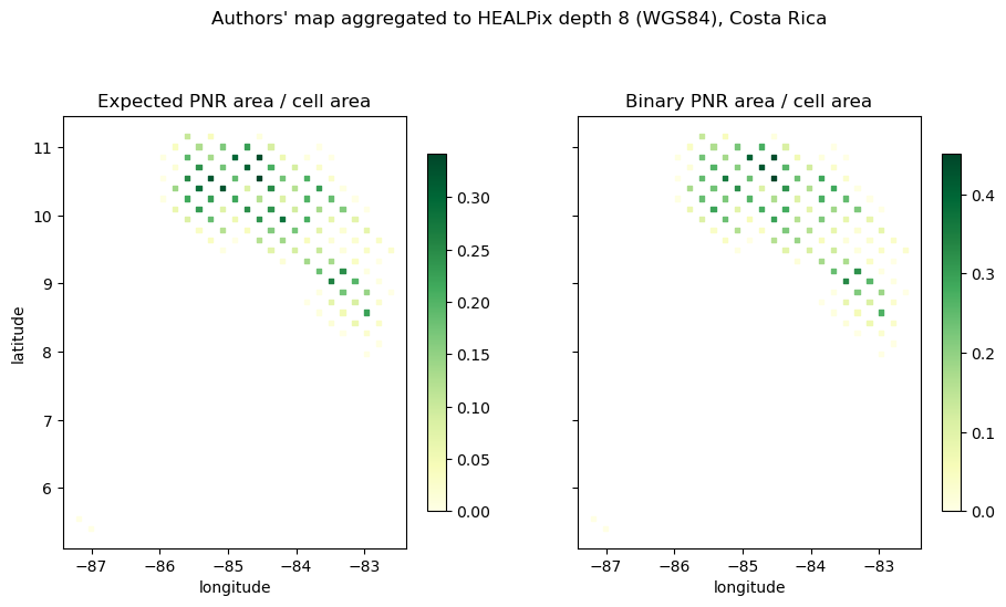
- Williams, B., Beyer, H., Fagan, M., Chazdon, R., Schmoeller, M., Sprenkle-Hyppolite, S., Griscom, B., Watson, J., Tedesco, A., Gonzalez-Roglich, M., Daldegan, G., Bodin, B., Celentano, D., Wilson, S. J., Rhodes, J., Alexandre, N., Kim, D.-H., Bastos, D., & Crouzeilles, R. (2023). The potential for natural forest regeneration in tropical regions. Zenodo. 10.5281/ZENODO.7428804